 |
| About Bioline | All Journals | Testimonials | Membership | News |
|
||||||
|
||||||
EFFECTS OF DIFFERENT SOIL TYPES AND RAINFALL VARIABILITY ON WATER STORAGE AND MAIZE YIELDS IN ZIMBABWE F. T. MUGABE Department of Research and Specialist Services, Chiredzi Research Station, Box 97, Chiredzi, Zimbabwe (Recreived 22 April, 1997; Accepted 13 November, 1997)
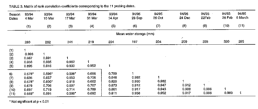
Code Number:CS98005 Abstract The amount of soil moisture available to crops after a rainfall event depends on the rainfall quantity, water redistribution and the water holding capacity of the soil. Often the variability in crop growth within short distances is related to the variability in soil type. Variability in soil moisture storage was determined on 14 plot which had a maize crop. Of the 14 plots tested, seven were on either side of the grey and red subcatchment which have sandy and clay soils respectively. Spearman's test was used to evaluate the time stability for water stored between zero and 100cm depth during the 1993/94 and 1994/95 seasons. The amount of soil moisture that was available to crops at Romwe catchment depended on the soil texture and the amount of rainfall in the 1993/4 and 1994/5 seasons. Water storage for both years was significantly correlated to silt + clay percent with coefficients of determinations of 0.385 and 0.8338 for the 1993/94 and 1994/95 seasons respectively and there was time stability in water storage between the two seasons considered. The differences in texture between the two areas and the year to year variation in rainfall explains the year to year variation in catchment maize yields. Key Words: Moisture availability, time stability, Zea mays RESUME La quantite d'humidite du sol disponible aux cultures apres les pluies depend de la quantite de celles-ci, de la repartition de l'eau et de la capacite de retention de l'eau du sol. Bien souvent la variabilite dans la croissance des cultures voisines est due a la variabilite du type de sol. La variation dans le stockage de l'humidite du sol a ete determinee dans 14 parcelles portent une culture de mais. De ces 14 parcelles testees, sept etaient du cote gris ou rouge du bassin hydrographique caracterise par des sols respectivement sableaux ou argileux. Le test de Spearman a ete utilise pour evaluer le temps de stabilite de l'eau stockee entre 0 et 100 cm de profondeur au cours des saisons 1993/94 et 1994/95. La quantite d'humidite du sol disponible aux cultures dans le bassin de Romwe dependrait de la texture et de la quantite d'eau de pluies tombees pendant les saisons 1993/94 et 1994/95. La retention d'eau pour les deux annees etait significativement corelee avec le pourcentage de sediment et d'argile dont les coefficients de determination etaient de 0,385 et 0,8338 respectivement pour les saisons 1993/94 et 1994/95. Il y avait donc une stabilite dans le temps de stockage d'eau entre les deux saisons considerees. Les differences dans la texture entre les deux surfaces et la variation des precipitations d'une annee a l'autre expliquent la variation interannuelle dans les rendements du mais du bassin. Mots Cles: Humidite disponible, stabilite dans le temps, Zea mays INTRODUCTION In semi-arid areas, rainfall is highly variable both in time and space, within and between seasons (Nicolson, 1980). Lebel et al. (1996) reported a seasonal difference of 275mm (39%) for two rain gauges just 9 km apart in the Sahel during the 1992 season. The relative water availability of soils is normally estimated by the available water capacity of the soil which depends on clay type, clay content, organic matter, structure and soil depth (Hussein, 1987). The available water capacity is important during the mid-season droughts because the lower the available water capacity of any given soil the shorter the period over which any crop can be sustained in the absence of rainfall (Henricksen and Durkin, 1985). Apart from soil variability, surface redistribution is also an important factor influencing soil moisture storage. Gaze, (1996) recorded 0.3 to 3.4 times water storage of the recorded rainfall for one 60mm storm in the Sahel. Moisture is extracted by a crop until wilting point is attained, thereafter, the crop will suffer from moisture stress. Carew (1973) used a 30 year period rainfall data to show that there was marked variations in length of season from year to year as well as the number of days on which soil moisture would be available to a maize crop in Mashonaland Intensive Conservarion Area. Soil variability and the associated crop variability can reduce farmers' yields, complicate agricultural management and can make interpretations of agricultural experiments more difficult (Bouwer et al, 1992). Communal area farmers in the semi-arid areas of Zimbabwe grow a number of crops including maize, sorghum, pearlmillet,cotton, groundnuts, and sunflower. There is not enough rainfall for crop production and even in wet years, crops like maize, may fail due to the much common midseason droughts. The objectives of this study was to investigate whether soil or rainfall has an effect on interannual catchment water storage and its implications on the observed interannual variation in maize yields in the Romwe catchment. This study is very important in understanding variations in crop yields in the semi-arid croplands of Southern Africa. MATERIALS AND METHODS The Romwe catchment, in Chivi, lies in natural region IV where rainfall is limited, erratic and poorly distributed. The natural regions are a classification of the agricultural potential of the country, from natural region I, which represents the high altitude wet areas to natural region V which receives low and eraratic rainfall averaging 550 mm per annum (Vincent and Thomas, 1960). The average annual rainfall at Chendebvu dam, a rainfall station located 12 km to the north of the catchment, over the last 40 years (1952-1992) is 581mm (Butterworth et al, 1995) with a standard deviation of 263mm. The catchment, which has an area of 4.6km^2 is comprised of three soil types mainly due to differences in parent material (Butterworth et al, 1995). Light grey coloured, sandy soils formed from the more granitic gneiss are found on the Southern side of the stream. These are kaolinitic, fersialitic soils (III 5P) according to the Zimbabwean soil classification system (Thompson and Purves, 1978). In many locations, the light textured surface horizons are underlaid by a thick clay layer. On the north of the stream, kaolinitic, fersialitic, red clays with granular micro-structure (III 5E) derived from more mafic pyroxene gneiss predominate. The third and least extensive soil type are small areas of vertisols (III 3E) which occur as the lower members of the catenal sequence on the north of the stream. There are 32 households in the catchment (Butterworth et al, 1995) whose main activity is subsistance agriculture and for many this is the only source of food and income. Fourteen maize plots were randomly selected, seven of which were within each of the red and grey subcatchments. Each farmer was supplied with a diary in which to record all the management perfomed in the field in which the plot was. One access tube (external diameter 45mm) was installed to 120 cm in the centre of each of the fourteen 10 m x 10 m maize plots. The same plots were maintained in the 1994/95 season, but some farmers cultivated a crop other than maize. A neutron probe (Wallingford MK III) was used to measure soil moisture. Counts were taken over 16 seconds at 10cm intervals on eleven dates between 16 February 1994 and 6 March 1995. Soil samples were sent to Centre of nuclear studies (Cadarache, France) for calibration of the neutron probe. Two sets of calibration equations, one for the red (equation 1) and the other for the grey (equation 2) soils were used to convert counts per second to volumetric water content.
           R
        10 -- + 1.2017 - 1.2538pb
           Rw
        -------------------------
             0.75pb + 9.64

          R
       10 -- + 1.0762 - 0.9863pb
          Rw
       -------------------------
             1.59pb + 9.3
where R is count in soil, Rw is count in water and rb is soil bulk density
g.cm^-3At 10 cm and 20 cm depth, the slopes of the calibration equations were multiplied by factors of 1.5 and 1.2 respectively. This was done so as to allow for neutron escape near the soil surface, which reduces the sensitivity of the probe to changes in water content (Dr. L. Simmonds, personal communication). At the end of the season, biomass from a 5 m x 5 m plot with the access tube located in the center were harvested and weighed. A subsample of four maize plants was taken at random, weighed, dried for 24 hours and reweighed for converting the sample to dry matter at 105 C. Particle size on each horizon for the 14 plots was measured at the Institute of Soils and Chemistry, Harare. Horizon delineation was based on colour and observable textural and structural differences. In this study, percent sand refers to the combination of coarse, medium and fine sand. The nonparametric Spearman's test (Vachaud et al, 1985) was used to evaluate time stability in the amount of water stored between 0 and 100 cm and is calculated by: Equation 2
              6 sigma(Rij1 - Rij2)^2
     rs = 1 - ----------------------
                   n(n^2 - 1)
where rs is the Spearman rank correlation coeffient. The closer rs is to 1,
the more stable is the ranking of the locations. Rij1 is the rank of a
variable observed at location and date j1 ;Rji2 is the rank of the same
variable at the same location but date j2; n is the number of
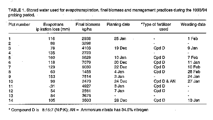
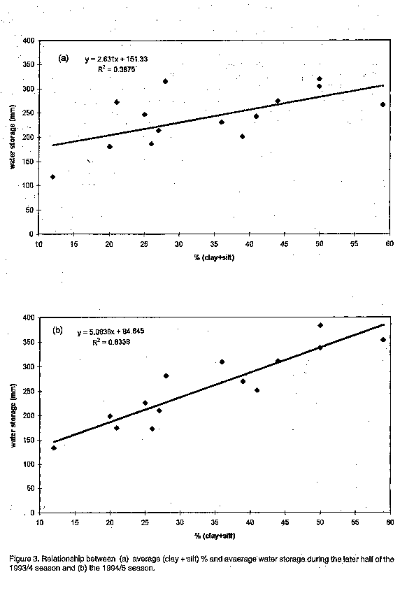
observations.The experiment was conducted during two years representing low and high rainfall. Total rainfall in the 1993/94 season was 661 mm of which 70% fell during November and December. The 1994/95 season was wetter, 735 mm was received with 70% falling during December to March. RESULTS Table 1 shows that maize planting dates ranged from 25 December 1993 to 10 January 1994. Compound D (8:15:7) is the most commonly used fertiliser and only one farmer topdressed his field with ammonium nitrate. Weeding dates were also variable, some farmers did not weed at all. Water use during the measurement period differed from plot to plot. On average the crop from the red subcatchment used 54% less water and gave 32% less biomass than that on the grey subcatchment. Figure 1 shows that the relationship between biomass at harvest and evapotranspiration is not significant (r2 = 0.2604). Figure 2 shows greater difference in water storage between the plots in the red subcatchment (1, 11 and 14) and those in the grey subcatchment (5, 7 and 9) during the wetter 1994/95 than the drier 1993/94 season. Figures 3a and 3b show that the average water storage in both seasons is related to clay + silt percent, with the 1993/94 season showing a stronger correlation than the 1994/95 season as showed by the coefficiences of determination of 0.3875 and 0.8338 respectively. Soils in the red subcatchment have, on average three times more clay content than those in the grey subcatchment in the first horzon (Table 2). Clay content remain constant with depth in the red subcatchment while there is, on average, a twofold increase in clay content from the first to the third horizon within the grey subcatchment. Table 3 lists the matrix of rank correlation coefficients corresponding to the 11 probing dates. The results can be divided into three gro water storage compared to the 1994/95 season. The 1994/95 season was a wetter season and therefore differences between profiles in water retention capacity were expressed more than the drier 1993/94 season. The absence of any relationship between water lost through evapotranspiration and biomass might have been a result of other limiting factors like presence/absence of weeds, differences in planting dates and soil fertility. Water loss through soil evaporation might have been different from the differeneriod between August to March 1995. As for the rank correlation coefficients relating these two periods, some are significant and some are not. DISCUSSION Plots 7 and 9 are sandy at the surface and this helped water conservation in the 1993/94 season whereas the clayey plots in the red subcatchment (1, 11 and 14) retained less water during the dry part of 1993/94 than during the wetter 1994/95 season. The 1993/94 season was a drier year and therefore the plots do not show much differences in profile water storage compared to the 1994/95 season. The 1994/95 season was a wetter season and therefore differences between profiles in water retention capacity were expressed more than the drier 1993/94 season. The absence of any relationship between water lost through evapotranspiration and biomass might have been a result of other limiting factors like presence/absence of weeds, differences in planting dates and soil fertility. Water loss through soil evaporation might have been different from the different plots and this resulted in t he an insignificant relationship between biomass and water loss through evapotranspiration. Weeds compete with crops for soil moisture. For example, plot 9 used 135 mm of water and produced the highest biomass yield even without fertilizers application. On the other hand plot 10, that was fertilised with both compound D and Ammonium nitrate, used 95mm of water only produced 2470 kg/ha while plot 11 which used 30mm of water, was fertilized with Compound D and produced 4927 kg/ha of biomass. On average more water was used and greater yield obtained from the sandy soils, though the sandy soil had slightly less moisture during the 1993/4 season because sandy soils retain less moisture at wilting point compared to clay soils. Management practices bring in a source of variability in yields under dryland agriculture in the semi-arid areas. There was a wide range in the planting dates of the plots assessed. A significant relationship between silt + clay percent and water storage (Fig. 3) was observed and there was time stability in water storage between the two years. This agrees with Vachuad et al.'s (1985) observation that time stability will occur if strong covariance exists between a spatial variable of interest and a deterministic factor such as texture. The observed absence of strong correlation (the shift in ranks or insignificant rs values linking the two seasons) between the two seasons can be attributed to a combination of factors such as differences in rainfall distribution during the two seasons, differences in clay content distribution with depth and differences in crop management. Differences in water storage as a result of differences in rainfall, texture and management practices explain the observed year-to-year variation in maize yields in the catchment. In dry years, the relatively low water holding capacity of the sandy, grey soil is an advantage compared to the heavy soils which require much water to bring them even to wilting point as was observed by Jones (1987). Because of the low water holding capacity, water will penetrate to greater depth than in the red clayey soils. There will be less water loss due to evaporation from the sandy soils compared to the clay soils . The mulch effect of the sandy soils results in a shorter first stage of drying (Lemon, 1956). The first stage of drying is prolonged in the clay soils because of the presence of more micropores than in sandy soils. This resulted in little differences in water storage between the sandy and clayey soils (Fig. 2) in the 1993/94 season. In a drier year, like the 1993/94 season, the grey subcatchment would be expected to give higher yields though water storage is almost the same as the red subcatchment. Water is not as tightly held in the grey, sandy soils as in the red clayey soils. In wet years there is water-logging in the grey subcatchment because infiltration is reduced at the third horizon due to the sudden increase in the clay content. Low yields are expected because of poor aeration and leaching out of nutrients. In wet years, yields are greater in the red subcatchment because the soil can hold more water to be used during the much frequent mid-season droughts. The grey, sandy soils lost most of the water as lateral flow in the 1994/95 season because of the dense clay layer at 70 cm depth (Doorenbos et al 1986). This resulted in big differences in the water content between the sandy and the clayey soils. The observed differences in the soils may help spread risks by subsistance farmers as was noted by Bouwer et al (1992) in the Sahel. Farmers with a piece of land in both the red and grey area would be assured of some yield in both wet and dry years. ACKNOWLEDGEMENT The work on which this paper is based was carried out with the aid of a number of collegues from DR & SS, IH and the University of Reading. I am indebted to Dr. Lester Simmonds of the Department of Soil Science, Reading University, E.Z. Nyakatawa, Dr. M.D.S. Nzima and P. Nyamugafata for their helpful comments. REFERENCES Bouwer, J, A. Buekert, R .D. Stern, R.J. Vandenbeldt and J.M. Powell. 1992. Soil and crop growth microvariability in the Sahel: Boon and Bane for farmers and Agronomists. In "The Proceedings of the third annual scientific conference. SADC Land and Water Management Research Programme. Harare, October 5-7, 1992. Butterworth, J.A., Lovell, C.J., Bromley, J., Mugabe, F.T. Batchelor, C.H. and Bastable, H. 1995. Romwe Catchment study: Effect of land management on groundwater recharge, and implications for small-scale irrigation using groundwater. Carew, G.W. 1973. Drought and maize yields in the Mashonaland Intensive Conservation Areas. Rhodesian Journal of Agriculture 70: 111-114. Clarke, G.M. and Cooke, D. 1992. A basic course in statistics.Third edition. Melbourne Auckland. Doorenbos, J, A.H. Kassam, C.L.M. Bentvelsen, V. Bransched, J.M.G.A. Plusje, M. Smith, G.O. Uittenbogaard and H.K. van Der Wal. 1986. Yield response to water. FAO Irrigation and Drainage Paper 33 pp 26. Gaze, S.R. 1996. Water balance of farmer-managed millet and fallow-savannah on sandy soils in South West Niger. Unpublished DPhil. Thesis. The University of Reading, Department of Soil Science pp50. Henrickson and Durkin (1985). Moisture availability, cropping period and the prospects for early warning of famine in Ethiopia. ILCA Bulletin no. 21 January pp 2-9. Hussein, J. 1987. Agroclimatological analysis of growing season in Natural Regions III, IV and V of Zimbabwe. In "Cropping in the Semi-arid areas of Zimbabwe". 24-28 August 1987. AGRITEX. Jones, M.J. 1987. Soil water and crop production in Botswana. Soil use and management,3:74-79 Lebel, T., Taupin, J.D. and N., D'Amato. 1996. Rainfall monitoring during HAPEX-Sahel: I. General rainfall conditions and climatology. Journal of Hydology (In press) Lemon, E.R. 1956. The potentialities for decreasing moisture evaporation loss. Soil Science Society of America Journal, 20: 120-175. Nicolson, S.E. 1980. The nature of rainfall fluctuation in subtropical West Africa. Monthly Weather Review 108:473-487. Thompson, J.G. and Purves, E.D. 1978. A guide to the soils to Rhodesia. Rhodesia Agriculture Journal, Technical Handbook No. 3. Vanchuad, G., Passerat De Silans, A., Balabanis, A. and Vauclin, M. 1985. Temporal stability of spatially measured soil water probability density function. Soil Science Society of America Journal 49:822-827. Vincent, V and R.G. Thomas. 1960. Agricultural survey of Southern Rhodesia. Part 1, Agro- Ecological Survey. Salisbury: Government Printers.
Copyright 1998, African Crop Science Society The following images related to this document are available:Line drawing images[cs98005g.gif] [cs98005c.gif] [cs98005b.gif] [cs98005d.gif] [cs98005a.gif] [cs98005f.gif] [cs98005e.gif] |
| |||||||||