 |
| About Bioline | All Journals | Testimonials | Membership | News |
|
||||||
|
||||||
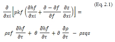
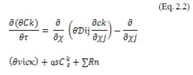
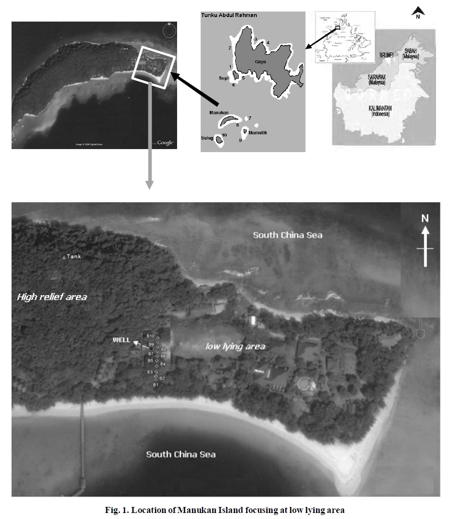
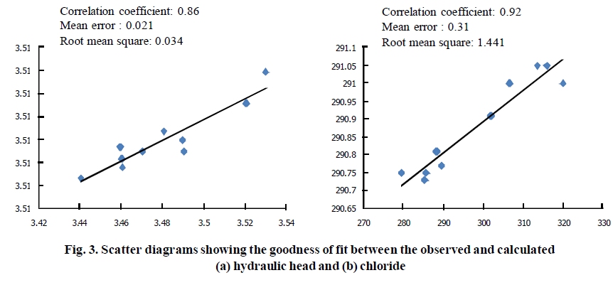
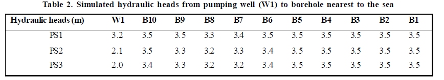
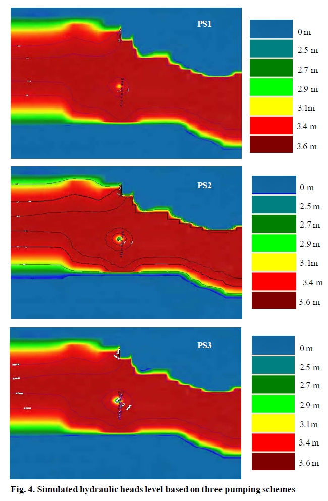
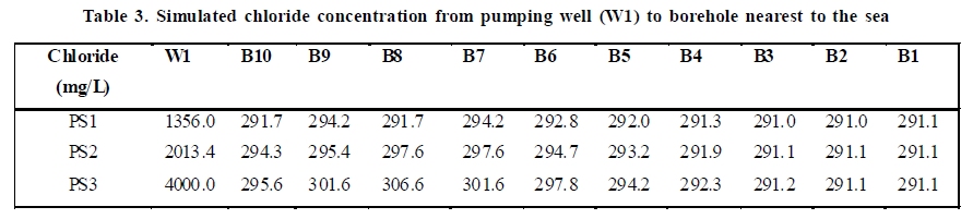
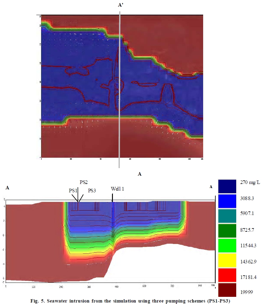
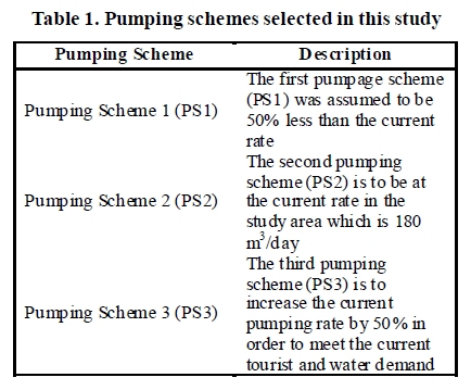
International Journal of Environmental Research, Vol. 4, No. 3, July-September, 2010, pp. 415-426 Article Modeling for equitable groundwater management Praveena, S. M . 1* , Abdullah, M. H . 1 and Aris, A . Z . 2 1 School of Science and Technology, Universiti Malaysia Sabah, 88999 Kota Kinabalu, Sabah, Malaysia Date of Submission: 12-Feb-2009 Code Number: er10045 Abstract Freshwater lens on small islands may easily be overexploited or polluted due to overdrafts of fresh water by pumping which causes drawdown of the water table a rise or up-coning of the saltwater interface. Present study is concerned with using a three-dimensional finite-difference numerical model to simulate the groundwater flow and transport model to predict the behavior of groundwater system in Manukan Island. The simulations were done using variable density SEAWAT-2000 for three selected pumping schemes. Hydraulic heads (groundwater level) is the highest at the center of the island and decreases in radial shape towards the coast in all the pumping schemes (PS1-PS3). The chloride concentration in the studied aquifer increased by 98.7% in the pumping well if the pumping rate is doubled by the current (PS2 to PS3). The 1.4% seawater-freshwater mixing moves further forward to inland about 1.6m when the current pumping rate was doubled whereas moves backward to sea about 1.7m if the current pumping rate is reduced by 50%. This preliminary model of Manukan island aquifer shows that an overexploitation of groundwater in Manukan Island contributes to the seawater intrusion. Adjusting the future groundwater pumping scheme and improving groundwater management strategies are necessary to protect the freshwater aquifers. The current numerical model is a reasonable representation of the aquifer in Small Island which can be used in similar small islands with similar hydrogeological conditions in elsewhere.Keywords: Small Island, Freshwater, Pumping rate, Groundwater management Introduction Small islands have limited alternatives to develop their freshwater resources. According to Aris et al. (2008), freshwater in small islands usually depends on recharge, quantity and surface storage. In small islands where surface water does not exist in exploitable form, fresh groundwater is the sole option to meet the water demand. In low coral atolls, groundwater exists as fresh-water lenses floating over saline transition zones, grad-ing into seawater (Abdullah et al., 2002). The freshwa-ter lens on small islands may easily be overexploited or polluted due to dense development combined with im-proper management, vulnerable to climate change and the associated impacts to freshwater resources. Over-drafts of fresh water by pumping well distort the natu-ral recharge-discharge equilibrium causes drawdown of the water table a rise or up coning of the saltwater interface. Greater withdrawals may not only create lo-calized up-coning, but also result in a regional reduc-tion in thickness of the freshwater lens (Rejani et al., 2008). Groundwater models apply the advantages of recent advances in computer technology to provide real time modeling, visualization and analysis of two and three dimensional flow and transport softwares (Welsh 2008; Abdul Rahim & Abdul Ghani 2002). Groundwater models are user friendly graphical inter-faces make it easier for models to be used (Konikow, 1996). Numerical groundwater models such as SEAWAT have dominated the study of complex groundwater problems because of their ability to tie data and physical principles together into a useful picture of the studied area as well as capable to pro-duce greater and accurate. Simulation of groundwater modeling is an excellent tool to understand the be-havior of an aquifer system subjected to artificial stresses such as pumping (Rejani et al., 2008). Ex-amples of SEAWAT-2000 applications in groundwa-ter flow and solute transport studies were presented in Balasore, India by Rejani et al. (2008), in Pionner Valley, Australia by Werner and Gallagher (2006), in Kyushu Island and Ariake Sea, Japan by Don et al. (2005), in Gaza aquifer as well as Palestine by Qahman & Larabi (2006). Thus, groundwater modeling has emerged as a powerful tool to help managers to opti-mize and predict the groundwater resources. Tourism impacts on small islands such as Manukan made more severe to their limited water resources and can reach a critical level easily (Wong, 1998). Famous dive sites have attracted more tourists to this island. This is supported by an increased in numbers of tour-ist arrivals to this island about 400% from 1997 to 2004 (Aris et al., 2008). This has resulted in tremendous increased of groundwater extraction to meet the groundwater supply and domestic needs. In addition, a total of eight dug wells in low lying area which have been used for groundwater extraction have been shut down due to incursion of seawater into the island's aquifer. Only one dug well is currently operating in groundwater extraction to meet the domestic supply. With this current situation, large pumping of ground-water will lead to the depletion of groundwater and deterioration in its quality. In general, small islands are highly susceptible to seawater intrusion due to its highly permeable aquifer. The carrying capacity, ecol-ogy and limits of acceptable change of these islands should be considered with an increased in tourism as-pect (Aris et al., 2008; Aris et al., 2007). Manukan Is-land revealed that the mixing rates of seawater intru-sion in low lying area of Manukan Island were about 13%. The seawater intrusion into Manukan Island's aquifer is marked by the presence of Na-Cl water type. Saltwater intrusion becomes a threat when the inter-face moves far enough inland to render drinking water wells salty and unusable. Intensive exploitation of groundwater and wells shutdown in Manukan Island's aquifer is indicators to indicate that the natural equi-librium between fresh and seawater has been disturbed. Therefore considering this fact, present study is con-cerned with using a three-dimensional finite-difference numerical model to simulate the groundwater flow and transport model to predict the behavior of groundwa-ter system affected by pumping rates. The simula-tions were done using variable density SEAWAT-2000 code (Guo & Langevin, 2002), a combined version of MODFLOW and MT3D for three selected pumping schemes.This preliminary output is to gain insights about the future changes in hydraulic levels and chlo-ride content resulting from pumping schemes selected in this study. Material & Methods Tunku Abdul Rahman (TAR) Marine Park is lo-cated at Sabah East Malaysia on the island of Borneo TAR has one of the perfect tropical islands, well de-veloped in terms of tourist facilities and most visited island in Sabah. TAR Marine Park covers an area of 4,929 hectares and boosts five excellent and idyllic tropi-cal islands (Sapi, Mamutik, Sulug, Gaya and Manukan). The TAR islands are easily accessible as they are close to Kota Kinabalu - about 15 to 20 minutes boat ride. Manukan Island (5557'-5 `58'N and 115 `59'-116 1 01'E ) in [Figure - 1] covers an area of 206,000 m2 surrounded by other magnificent small islands such as Sapi, Mamutik and Sulug. The crystal clear waters and white sandy beach of Manukan island is an ideal location for snorkeling, diving and swimming This boomerang shaped tropical island is the second largest of the TAR Marine Park and has good stretches of beaches especially on the southern coastline. Almost 80% of the area is covered by dense vegetation on high relief area (eastern side), while the rest of the area is located on the low lying area of the island (western coastline). The flat low lying area of the island has been developed for tour-ism activities. There is also accommodation available with excellent facilities and good infrastructure sup-port (Aris et al., 2008; Aris et al., 2007; Abdullah et al., 2002). The island is about one and half kilometers long and three kilometer wide in the middle. The topogra-phy of the island is relatively hilly land with maximum elevations of approximately 60 m in the western and decreasing elevation towards the eastern coast.The area has a warm and humid climate and receives an-nual rainfall between 2,000 and 2,500 mm. Humidity ranges between 80% and 90% whereas temperature is between 21ξ C to 32ξ C. The island consists of uncon-fined sandy aquifer, underlain sedimentary rock (sand-stone and shale), is a part of the Crocker range rock formation of the western coast of Sabah deposited during Late Eocene to Middle Miocene (Basir et al., 1991; Abdullah et al., 1997). The sedimentary rock of Manukan Island dips towards the low lying area (east-northeast) with dipping angles of 15ξ - 45ξ . The sedi-mentary rock forms a slight symmetrical syncline in the low area and can be observed in several locations around the island (Abdullah et al., 1997). Shale con-sists of clay and mud, typically deposited in very slow moving water and is often found in lake and lagoon deposits, as well as offshore of beach sands; they can also be deposited on the continental shelf (seabed), commonly in quiet water. While most sandstone is composed of feldspar and/or quartz as these are most common minerals in the Earth's crust. Rock formations which are primarily sandstone usually allow percola-tion of water can store large quantities. These charac-teristics create them as valuable aquifers (Sparks, 1995, Manahan, 2000). Abdullah et al. (2002) conducted a study on the morphological of the island found that the thickness of the aquifer from the ground surface to bedrock are approximately, 5.7 m (northern part), 11 m (southern part) and 12 m (at the middle). Generally, the profiles at low lying area are flatter and thinner than hilly area. The regional groundwater flow is mainly towards the South China Sea. The medium of the aquifer consists of fine to coarse sand mixed with some fine gravel. The parent materials at hilly area of the island are sand-stone and mudstone whereas in the low lying of the island is alluvium. Alluvium acts as a sufficient water storage which solely depends on its thickness. On the low lying area of Manukan Island, the small area and low elevations lead to very limited water storage (Abdullah et al., 2002). Low lying area from the hilly area to shoreline was selected for this study. This is because the low lying area has been developed for tourism activities and all the wells for groundwater extraction are located on the low lying area of the island (8 wells have been shut down and only 1 well is currently operating). Total of 10 boreholes were constructed and installed by hand auger manually to a depth of between 1-3.5 m in the aquifer. The soil samples were taken into lab for soil physical parameters (hydraulic conductivity and po-rosity). A pumping well and 10 boreholes were distrib-uted across the study area [Figure - 1] to provide a good horizontal and vertical spatial distribution of hydro-logic data. The operation of the pumping well and the boreholes will be able to show the changes in hydrau-lic levels and chloride content resulting from pumping from shoreline. Hydraulic heads and chloride data were collected from October 2008-February 2009 from the well and boreholes. Water samples were pumped through silicon tubing to polyethylene sampling bottles via a peristaltic pump. Analysis for chloride was done using argentometric method (APHA, 1995). SEAWAT-2000 is the latest modeling software available in groundwater modeling that couples flow and transport together (Guo & Langevin, 2002). SEAWAT-2000 couples the flow and transport equa-tions of two widely accepted codes MODFLOW (Mcdonald & Harbaugh, 1988; Harbaugh et al., 2000) and MT3DS (Zheng & Wang, 1999) with some modifi-cations to include density effects based on the ex-tended Boussinesq assumptions. It reads and writes standard MODFLOW and MT3DS input and output files so that most existing pre- and post processors of those packages can be used. The governing flow and transport equations in SEAWAT-2000 are as in Eqs 2.1 and 2.2.
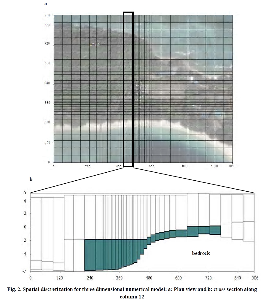
Where; Xi = ith orthogonal coordinate K f =equivalent freshwater hydraulic conductivity (L/T) S f = equivalent freshwater specific storage (1/L) h f = equivalent freshwater head t= time (T) θ= effective porosity (dimensionless) ps = density of source and sink (M/L 3 ) q s = volumetric flow rate of sources and sinks per unit volume of aquifer (1/T) The transport equation is as followed :
Where: C k = dissolved concentration of species, k (M/L 3 ) D ij = hydrodynamics dispersion tensor (L 2 /T) Cks = concentration of the source or sink flux for species, k (M/L 3 ) ∑Rn = the chemical reaction term (ML 3 /T) One advantage of SEAWAT-2000 is that it uses MT3DMS to represent solute-transport, the program contains several methods for solving the transport equation including the method of characterization, a third-order total-variation-diminishing (TVD) scheme, and an implicit finite-difference method (Langevin, 2001).Hence, SEAWAT-2000 software package was selected in the present study to simulate the ground-water flow and solute transport to predict the behav-ior of groundwater of Manukan Island aquifer. The conceptual model for this study was devel-oped based on the surface elevation contour map, in-formation collected during boreholes construction and data from Abdullah (2001). An important tool to char-acterize the aquifer is hydrogeological profiles. The low lying area of Manukan Island unconfined aquifer is consist of fine to coarse sand mixed with gravel. The sandstone has about same thickness with the car-bonate deposits in low lying area. In the plan view [Figure - 2], the model grid consists of 28 columns and 30 rows with grid spacing of 1093 (x-direction) and 906 m (y-direction). The unconfined layers divided into 2 layers based on the hydrogeological information. The surface elevation, groundwater elevation and ground-water data (hydraulic head and chloride) were made in Excel format and fed as input in the model. The top elevation of layer 1 corresponds with island land el-evation. The bottom of layer 2 is set at an elevation of 7.0 m below the mean sea level. The aquifer is recharged by rainfall, as there is no any surface water available. The study area is hydraulically bounded by South China Sea. Based on groundwater level data availability, one day was chosen as the time step and to be increased by a multiplier factor by 1.2 within which all the hydro-logical stresses can be assumed constant. According to Spitz & Moreno (1996), time step is required for transient state. Generally, the smaller the time step, the more accurate the predicted results although it will require excessive computation time. Too large time steps will result in instability output. As this current study with limited data acts as a preliminary numerical modeling in Manukan Island, one day was chosen as a time step to present the predicted values in hydraulic heads and chloride. Samples collected during the bore-holes construction were analyzed to determine the hydraulic conductivity. Hydraulic conductivity was estimated using well-known Hazen equation (Freeze & Cherry, 1979). This method has been successfully used in groundwater modeling studies to determine hydrau-lic conductivity by Rejani et al. 2008 (Eq. 2.3). All the values are averaged for each zone and the mean hori-zontal hydraulic conductivity is assigned for the en-tire layers. Hydraulic conductivity of aquifer is deter-mined to be 9.49 E-5 m/day in Layer 1, while layer 2 is assigned a value of 1.34 E-5 m/day. However, for all the layers, vertical hydraulic conductivity is estimated as 5% of the horizontal hydraulic conductivity as done by Lin et al. (2008) in Alabama Gulf coast, USA. K = 0.01d210 (E.q 2.3) Where, K = hydraulic conductivity (m/s) and d210 ef-fective size of the particle (mm) determine by grading curve. Recharge is applied to the uppermost active layer. An average rate of 600 mm/year and was consumed constant throughout the study. Effective porosity is assumed to be homogeneous and set to 0.30 as an initial estimate. Longitudinal dispersivity is also con-sidered to be homogeneous in the flow system and is initially set to 1 m. The ratio of the horizontal trans-verse dispersivity to the longitudinal dispersivity is assumed to be 0.1 while the ratio of the vertical trans-verse dispersivity to the longitudinal dispersivity 0.01. The model has been set up to simulate seawater intru-sion into coastal aquifers simultaneously involving both groundwater flow and solute transport processes. For flow model, constant head boundary was consid-ered for the sea. The constant head values are either zero representing the mean sea level or interpolated from the measures heads along the boundaries. For solute transport, chloride was considered in order to explain the seawater intrusion. The chloride concen-tration in seawater and freshwater is approximately 19, 999 and 250 mg/L respectively. For the reason of data availability, October 2008 hydraulic heads levels and chloride concentration were used as the initial condi-tion. In this study, model calibration is achieved through trial and error approach by adjusting the value of hydraulic conductivity. Model calibration was based on trial and error method as done in various groundwater modeling studies (Rejani et al., 2008). The adjustment was made until the hydraulic head and chlo-ride concentrations observed in well as well as bore-holes match the observed values to a satisfactory degree. The calibrated and validated model could now be used for a variety management and planning studies. In predictive simulation, the parameters optimized dur-ing calibration are used to predict the system response to future events. Predictive simulations were performed to minimize the overexploration in the unconfined aqui-fer of Manukan Island. Three pumpage schemes were selected used for a variety management and planning studies. Results & Discussion In this study model calibration is achieved through trial and error approach by adjusting the zonation and values of hydraulic conductivities until the hydraulic head values calculated by SEAWAT-2000 match the observed values to a satisfactory degree at the end of simulation. The similar approach was used by Lin et al. (2008) in Alabama Gulf Coast, USA. Due to the fact that this is a preliminary study, limited data of observed chloride concentrations, no attempt is made to adjust several transport parameters including dispersivity and effective porosity. The values of dispersivity and ef-fective porosity remain the same as initially assigned. During calibration, a total of 55 observed hydraulic head and chloride values measured from October 2008 to February 2009. Model calibration is stopped when a reasonable match between the observed and calcu-lated hydraulic head and chloride are achieved. As il-lustrated in [Figure - 3] overall correlation coefficients of 0.86 and 0.92 were obtained for the model calibrations outputs. The model calibrations indicating a reason-ably good match between observed and calculated hydraulic head and chloride. It is noteworthy that the model calibration performed for this study is the pre-liminary nature due to the limited number and duration of the observation data. Therefore, additional model calibration should be attempted when more field data become in the future with the continuous monitoring in study area. The fluctuation of hydraulic heads in the island is influenced by recharge, pumping of groundwater, tidal, etc (Hahn et al., 1997). Hydraulic heads generally range from 3.4 to 3.7 m at flat low lying area. The high relief area acts as recharge area, the groundwater flow is directed downwards to low lying area. In order to demonstrate the effect of pumping scheme in study area, three pumpage schemes were selected. The first pumpage scheme (PS1) was assumed to be 50% less than the current rate. The second pumping scheme (PS2) is to be at the current rate in the study area which is 180 m 3 /day. The third pumping scheme (PS3) is to increase the current pumping rate by 50% in order to meet the current tourist and water demand. [Table - 2] shows the hydraulic heads and chloride values simu-lated by three pumping scheme. The simulated values of hydraulic heads were from the pumping well (W1) to borehole nearest to sea (B1). It can be noticed that boreholes near to the pumping area (B6-B8) showed decreased in hydraulic heads level compared to bore-holes which are far than pumping area (B1 or B10). [Figure - 4] is the contour maps of hydraulic heads of three predictive pumping schemes simulations for the un-confined aquifer of Manukan Island at the end of the simulation. Groundwater resources are the major reliable source of water supply in Manukan Island. Hydraulic heads (groundwater level) are the highest at the center of the island and decreases in radial form outward to-wards the coast in all the pumping schemes (PS1-PS3). Lowering the hydraulic heads in Manukan Island due to pumping will result the movement of the saline wa-ter into the aquifer by the lateral and upward invasion of the seawater to the aquifer (Shammas & Jacks, 2007). As the number of tourists plunged year by year, the demand of groundwater pumping intensities were ex-pected to increase. With an increase of 50% of current pumping rate (P3), it shows that the hydraulic heads became lower than pumping scheme PS1 by 60%. This figure suggests a significant reduction of the future subsidence if the pumping rate was restricted in loca-tions where pumping has been intensive.The decrease in the hydraulic heads in the well field area may lead to seawater intrusion due to pumping effect and sea. [Table - 2] shows the simulated hydraulic heads at three pumping schemes indicates the corresponding cone of depression. It can be seen that the groundwa-ter pumping has caused the water level in the island aquifer's to greatly fluctuate throughout the surround-ing coastal area. It resulting the development of cones of depression in heavy pumping rate. According to Don et al. (2005), as groundwater storage is depleted within the radius of influence of pumping, water levels in the aquifer decline. The rate and duration of pump-ing control the size of cone. Depend on storage char-acteristics, the water transmitted through the geologic materials to the well. Development of cone of depres-sion could results in an overall decline in hydraulic heads, change the direction of groundwater flow within an aquifer. Moreover, as water is pumped out from the aquifer until the hydraulic heads values in the grid cells near the sea boundary becomes very closer to the constant head along the boundary, any further in-crease in pumping rates will create the head in nearer cells to be less than the constant head along the sea indicating the seawater intrusion into the aquifer. The chloride concentrations of the groundwater are impor-tant when dealing with controlling measurement of seawater intrusion is taken into account. Paniconi et al. (2001) showed a strong and direct link between groundwater extraction and seawater intrusion. This is because decreased pumpage in the area has been considered as the main measure for controlling the ef-fects resulting from groundwater withdrawal. There-fore, groundwater solute transport will be discussed in next subchapter. On an island, the chloride concen-tration is an indicator of the amount of seawater that has mixed with the fresh rainwater infiltrated to the freshwater-lens system (Gingerich, 2003). Besides, the chloride concentration also showed that as the de-mand for groundwater pumping intensities increased, seawater intrusion in Manukan Island is expected to be more severe [Table - 3] . According to a study done by Mao et al. (2006) in Ardeer (Scotland), seawater intrusion occurs in two ways: one is the advancement of the seawater at the bottom of the aquifer result from the density difference between seawater and freshwa-ter. The other was the infiltration of seawater through the beach. The chloride concentration in the studied aquifer increased by 98.7% in the pumping well if the pumping rate is doubled by the current (PS2 to PS3). On the other hand, the chloride concentration simulation showed a decrease of 32.6% if the current pumping rate is lowered by 50% (PS2 to PS1). Thus, this output shows that with the current increasing number of tour-ists to Manukan Island, an increase in the pumping rate will cause seawater intrusion into the pumping well. The chloride simulation showed that seawater in the lower most mixes with freshwater as the seawater migrates upward through vertical zone and laterally within the Manukan Island's aquifer toward pumping well. The lowermost unit continues to supply seawa-ter into the current pumping scheme (PS2), as the pump-ing continues the seawater persists to follow the indi-rect path toward the pumping sites. Similar condition has been observed in Brunswick (USA) by Payne et al. (2001). Gallardo & Marui (2007) indicated pumping ac-tivities altered the long term equilibrium and produced a readjustment of the transition zone, which turned the routes of groundwater discharge into pathways for seawater intrusion. [Figure - 5] shows the infiltration of seawater through the beach. A cross section [Figure - 5] was selected to show the infiltration of seawater through the beach to the aquifer. At the cross section selected, about 1.4% seawater-freshwater mixing con-centration contours for selected pumping schemes (PS1-PS3) indicate a clear large mixing zone was formed underneath the beach surface.The 1.4% seawater-fresh-water mixing moves further forward to inland about 1.6m when the current pumping rate was doubled from PS2 to PS2. In contrast, the 1.4% seawater-freshwater mixing moves backward to sea about 1.7m if the cur-rent pumping rate is reduced by 50% (from PS2 to PS1). Seawater-freshwater mixing concentration of 1.4% was chosen to indicate that the mixing concentration ex-ceeds the maximum concentration level reported by USEPA (1992). This explains that the water is no longer potable for drinking water purposes and additional water treatment is needed or well discontinued opera-tion will be required. According to Mao et al. (2006), the contours are influenced by the complex hydrody-namics generated under the mildly sloping beach. This result is in agreement with that of Mao et al. (2006) in Ardeer (Scotland) and Chen & Hsu (2004) who used a two-dimensional time-independent finite difference model to simulate tidal effects on the intrusion of sea-water in either a confined or phreatic aquifer. The study focused on a sloped beach face. The studies concluded the seawater intrusion increases with the slope of the beach. Mao et al. (2006) indicated that on a sloping beach promotes intrusion as not only is a large area of seawater infiltration formed under the beach surface but also the advancement of the seawater at the bot-tom of the aquifer greatly increased. Chen & Hsu (2004) also stated that seawater intrusion on sloped beach faces accounting for tidal effects. Tidal effects enhance the migration of seawater. Moreover, Mao et al. (2006) and Ataie-Ashtiani et al. (1999) elaborated in small beach slope, it will enhance the tidal effects on coastal groundwater dynamics (flow and transport solute). Jocson et al. (2002) supported the fact that in small carbonate islands with high horizontal conductivity, the elevation of the hydraulic heads is strongly influ-enced by tide and sea level. Thus, in future studies of Manukan Island, tidal effects should be focused as a part of seawater intrusion study. Results of the predictive pumping schemes showed reasonable calculations of the hydraulic heads and chloride concentrations as well as the extents of seawater intrusion into the coastal aquifer. This pre-liminary model of Manukan island aquifer suggests that an overexploitation of groundwater from the coastal aquifer is the most important factor that causes sea-water intrusion in the study area. Thus, adjusting the future groundwater pumping scheme and improving groundwater management strategies will be necessary in order to protect the freshwater aquifers from being contaminated by seawater. The first pumping scheme (PS1) among the three pumping schemes simulated in this study (PS2 and PS2), was promising. As a result of the present numerical simulations on the aquifer system in the area, seawater intrusion would be ex-pected at the pumping well if the current rate (PS2) of groundwater exploitation continues. However, water budget referring to the accounting of water in and out need to be identified to ensure the PS2 pumping scheme will retain the sustainability of the freshwater in Manukan Island. Instead, an alternative to eliminate pumping rate about 50% could limit the seawater intrusion significantly about 32.7% in pumping well con-centration and reduced a clear large mixing zone was formed underneath the beach surface. Seawater intru-sion problem is a long term phenomenon that requires long-term remediation. As the tourist and the demand for groundwater pumping intensities continue to grow, it can be expected the actual extent of seawater intru-sion in future will be more severe than the model pre-diction. Although desalinization of seawater is proven to be feasible but frequently due to financial con-straints, reliance has to be placed upon groundwater abstraction in groundwater of coastal aquifers (Bobba, 1998). According to Bobba (1998), providing safe drink-ing water to the people and tourists is the reachable goal and the aim of every islander. It will take a major, long term effort on the part of the local government to improve water supplies in Manukan Island. Future models with consideration of more input data and model construction, model prediction can be conducted in study area. The collection of more data of study area is necessary for future numerical model development of Manukan Island. The numerical model output is crucial in order to protect the freshwater re-sources in coastal aquifers. Since the Manukan aqui-fer is the single most important source of water, appro-priate investments should be made to ensure that each of major components of hydrological water budget are adequately quantified, understood and incorporated in the future model. Conclusion This provides a valuable preliminary example for studying groundwater flow and solute transport with three different pumping schemes in small island coastal aquifer. The study has demonstrates that the SEAWAT-2000 code can serve as an effective tool for variable-density flow and transport simulation under complex geometries and geological settings. Given the uncertainties in the available data however in general the model reasonably simulates the hydraulic heads and seawater intrusion three different pumping schemes (PS1, PS2 and PS3) in small island coastal aquifer. Hydraulic heads (groundwater level) is the highest at the center of the island and decreases in radial form outward towards the coast in all the pump-ing schemes (PS1-PS3). Lowering the hydraulic heads in Manukan Island due to pumping will result the move-ment of the saline water into the aquifer by the lateral and upward invasion of the seawater to the aquifer. The chloride concentration in the studied aquifer in-creased by 98.7% in the pumping well if the pumping rate is doubled by the current (PS2 to PS3). An alterna-tive to eliminate pumping rate about 50% could re-duced significantly about 32.6% in pumping well con-centration and reduced a clear large mixing zone was formed underneath the beach surface. The 1.4% sea-water-freshwater mixing moves further forward to in-land about 1.6m when the current pumping rate was doubled from PS2 to PS2 whereas moves backward to sea about 1.7m if the current pumping rate is reduced by 50% (from PS2 to PS1).This preliminary model of Manukan island aquifer shows that an overexploitation of groundwater from coastal aquifer of the island is the most important factor that contributes to the sea-water intrusion. Therefore, adjusting the future ground-water pumping scheme and improving groundwater management strategies will be necessary in order to protect the freshwater aquifers from being contami-nated by seawater. The current numerical model is rea-sonable representation of the aquifer in Small Island which can be used in similar small islands with similar hydrogeological conditions in Malaysia and else-where. In the future, as new data become available, the model should be update periodically to refine esti-mates of input parameters values and simulate new management options. Acknowledgements The financial support through Ministry of Science, Technology & Innovation, Malaysia (ScienceFund: 04-01-10-SF0065) is gratefully acknowledged. The authors wish to express their appreciation to Sabah Parks for their permission to conduct this study in Manukan Island. Special thanks are due to Lin Chin Yik, Li Ying Chua, Jay Jim and Ng Kuan Leang for their assistance during fieldwork.[37][Table - 1] References
Copyright 2010 - International Journal of Environmental Research The following images related to this document are available:Photo images[er10045t1.jpg] [er10045f1.jpg] [er10045f2.jpg] [er10045t3.jpg] [er10045f3.jpg] [er10045f5.jpg] [er10045f4.jpg] [er10045t2.jpg] |
| |||||||||
