 |
| About Bioline | All Journals | Testimonials | Membership | News |
|
||||||
|
||||||
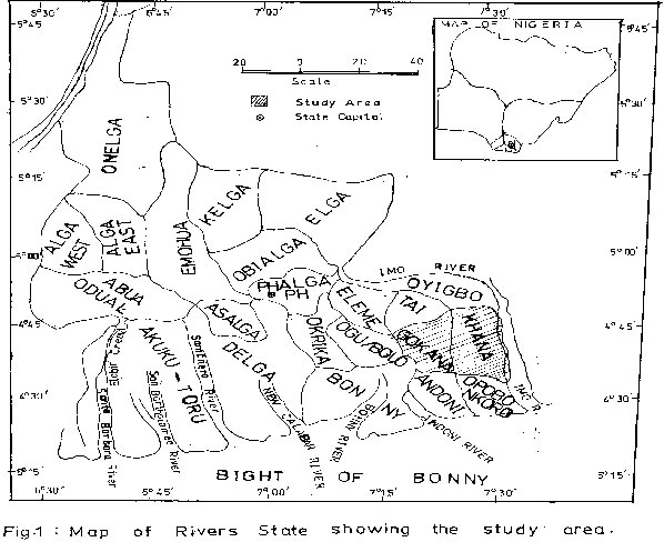
Journal of Applied Sciences & Environmental Management, Vol. 6, No. 1, June, 2002, pp. 53-59 A Geochemical Survey of Groundwater in Khana and Gokana Local Government Areas of Rivers State, Nigeria *Udom, G J; * Ushie, F A; ** Esu, E O * Geology Department, University of Port Harcourt, P. M. B. 5323, Port
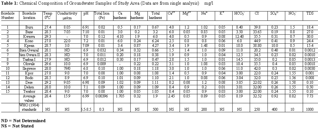
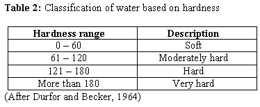
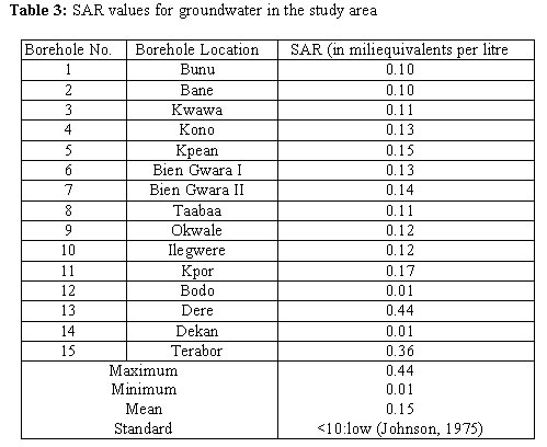
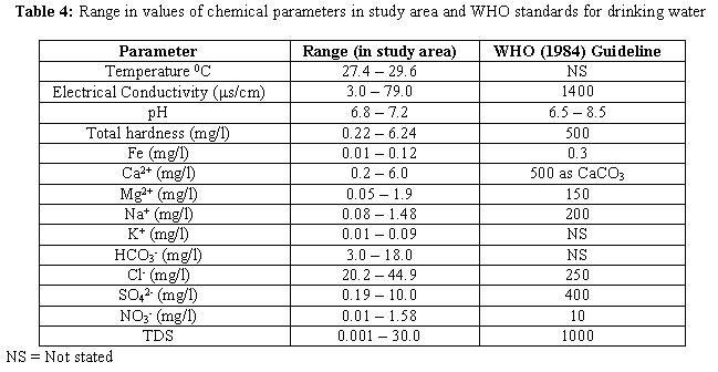
Harcourt, Nigeria. Code Number: ja02012 ABSTRACT: Fifteen groundwater samples from functional boreholes in Khana and Gokana areas of Rivers State were collected and analysed for various physico-chemical parameters using standard field and laboratory techniques. This was done to assess the suitability of the water for domestic and other purposes on the basis of the parameters studied. Results show the following mean values for the physical parameters: temperature, 24.8°C; Electrical Conductivity (EC), 15.9 ms/cm. For the chemical parameters, the following average concentration levels were obtained: pH 6.99; total iron, 0.04mg/l; magnesium 0.85mg/l; sodium, 0.89mg/l; and potassium 0.05mg/l. Others include bicarbonate, 8.19mg/l; chloride 32.52mg/l; sulphate, 0.92mg/l; nitrate, 0.82mg/l; and Total Dissolved Solids (TDS), 7.73mg/l. These results show that the groundwater in these areas is slightly acidic to slightly basic, soft and low in dissolved constituents. Chloride contents in the water show salt-water encroachment into the aquifers in both areas. However, when compared with the World Health Organisation (WHO) standards for drinking water, the results show that the water is suitable for drinking and other domestic purposes in view of the parameters determined. It is also suitable for agricultural purposes. The major sources of ions in the water include mineral assemblages in the rocks, geochemical processes operating within the groundwater system, as well as atmospheric precipitation. Moreover, these geochemical processes, and exploitation of water from different depths are suggested as reasons for the variations in the geochemical parameters with borehole locations. @JASEM Potable water is an essential ingredient for good health, and socio-economic development of man. It played a crucial role in the development of earliest civilizations in some parts of the world, for example, in the valleys of Tigris and Euphrates, Nile, Indus and Yellow River (Jayaraman, 1990). But in the past, only little attention was given to the problems and impacts associated with water consumption. Today, advances in science and technology have brought into limelight the gains of good quality water in the health profile of any community, as well as in agricultural and industrial processes. Consumption of water which has not met internationally acceptable standards could lead to an attack by any water-borne disease such as cholera, typhoid fever, and others. The people of Khana and Gokana areas use groundwater mainly for drinking and other domestic purposes. Considering the fact that some industrial activities which could affect groundwater negatively abound in the area, it has become necessary to study the quality status of the water. This is done to assess the suitability of the water for drinking by comparing the results of the analysis with WHO (1984) standards for drinking water. These are the standards also adopted by the Federal Environmental Protection Agency (FEPA). The suitability of the water for other uses have also been looked at. The study was carried out during a rural water supply programme. The outline of the programme involved location of suitable boreholes sites by geophysical surveys, actual drilling of boreholes, and finally, an evaluation of the quality of water from the boreholes. This paper is a report of the work done on the final lap of the project. Some basic physical and chemical constituents of the water have been looked at to assist in evaluating the quality of the water. All the boreholes studied tap water from the unconfined aquifers of the Benin Formation (also known as Coastal Plain Sands). They range in depths between 30m and 90m. THE STUDY AREA The study area is located in the Niger Delta Basin between latitudes 4°33' and 4°50'N and longitudes 7°20' and 7°35'E (Fig. 1). It is characterised by alternate wet and dry seasons (Iloje, 1972), with annual total rainfall of between 160mm and 298mm; relative humidity of over 90% and mean temperature of 27°C. The detailed geology of the area has been described by Allen (1965), Reyment (1965), Short and Stauble (1967). Generally, three major formations form the stratigraphic sequence of the Modern Niger Delta. They are the Benin, Agbada and Akata Formations in order of increasing age. The Benin Formation consists of poorly cemented sands, medium to coarse in size and Miocene to Recent in age. Environment of deposition is probably continental. The Agbada Formation consists of alternating deltaic (fluvial, intertidal and fluviomarine) sands and shales, while the Akata Formation consists of low density, high-pressure possibly deep marine shales. The Benin Formation is the aquiferous layer and all boreholes in the area are drilled into it. Minor intercalations of shale layers give rise to a multi-aquifer system, out of which two types have been identified (Etu-Efeotor, 1981). The first one (Holocene age) is more prolific and extends to about 60-90m (unconfined) while the second (Oligocene) is less prolific and underlies the first. Multi-aquifer systems have also been identified from lithologic logs of boreholes from other parts of the Niger Delta by Offidile (1992), Edet (1993), Udom et al (1988, 1999). Pumping tests in the area shows transmissivity values of 1000 - 8000m2/day and hydraulic conductivity of 5-55m/day. Static water levels range from 2m to 38m and the range of borehole depths falls between 30m and 90m. SAMPLING AND ANALYTICAL TECHNIQUES Water samples were collected from 15 boreholes into 1000ml plastic sample bottles with caps. Before sample collection, the borehole was allowed to pump for about 20 minutes so that the water with a constant temperature and pH, representing that from the aquifer could be sampled. After sampling, the bottles were tightly covered to minimize oxygen contamination and the escape of dissolved gases. The samples were collected at the well heads and taken to the laboratory in coolers for analysis within 24 hours. Conductivity, temperature and pH were determined in the field because of their unstable nature while the rest were analysed in the laboratory using standard analytical techniques with Buck Scientific Atomic Absorption/Emission Spectrophotometer 200A (AAES). This equipment gives a confidence level of 95% for the results. RESULTS AND DISCUSSION The results of the analysis of the groundwater samples in the study area are shown in Table 1. The average temperature of the water samples is 28.4°C, with a minimum value of 27.4°C and a maximum of 29.6°C. The temperature values were found to remain approximately constant throughout the duration of the fieldwork; an advantage groundwater has over surface water. pH values range from 6.8 in Ilegwere to 7.2 in Kono. These values indicate that groundwater in the area is slightly acidic to slightly basic. However, all the samples have met the standard of 6.5 to 8.5 stated by WHO (1984) for drinking water. The slight acidic nature of the water (for those with pH <7) could be attributed to the abundance of organic matter in the overlying soils or the presence of tiny shale intercalations in the aquiferous Coastal Plain Sands. Free Carbon dioxide (CO2) resulting from gas flaring in the area can also enter into the groundwater system from the atmosphere during precipitation and reduce the pH. Acidic waters favour the growth of iron bacteria which cause incrustation of pipes. Total Dissolved Solids (TDS) range in value from 0.001mg/l to 30mg/l with an average of 7.73mg/l. This is far below the stipulated value of 1000mg/l by WHO (1984) for drinking water, hence, the water is not harmful in view of this parameter. The water is also suitable for irrigation. Total hardness ranges from 0.22 - 6.24mg/l in concentration, indication that the water is soft (when compared with Table 2) and suitable for domestic uses. This water would foam easily with soap and encrustations are unlikely when it is heated. Conductivity values range from 3.0ms/cm to 79ms/cm with an average of 15.9ms/cm in the water (Table 1). The low values make the water suitable for irrigation. Conductivity values up to 2000ms/cm are permissible for irrigation (Wilcox, 1955). The cations determined in this study include Fe2+, Na+, Ca2+, K+ and Mg2+. The values of iron and sodium in the water are in the ranges of 0.01 to 0.1mg/l and 0.08 to 1.48mg/l respectively. These are below the stated values of 0.3mg/l for iron and 200mg/l for sodium in WHO (1984) standards for drinking water. The mean concentration levels of calcium, potassium and magnesium in the water are 2.45mg/l, 0.05mg/l and 0.85mg/l respectively. These averages, or even their maximum values (Table 1), are too low to make the water not suitable for domestic or agricultural use, but for industrial use, treatment for any of these parameters depends on the industrial process in view. Due to its deleterious effects on soils and plants, sodium is considered a major factor governing the choice of water for irrigation (Hem, 1985). Suitability of water for this purpose is based on Sodium Adsorption Ratio (SAR), which was calculated for the water samples based on the formular provided by the U.S. Salinity Laboratory (1954) as follows: where ion concentrations (in parentheses) are expressed in milliequivalents per litre.
The results got (Table 3) show low values (0.44<SAR<0.01)
implying that the water is suitable for irrigation in view of the contention
by Johnson (1975) that SAR values below 10 are considered low. Low SAR values
in groundwater in other areas of the Niger Delta have been reported by Udom et al (1998,
1999). High SAR values could cause sodium to replace adsorbed calcium or magnesium,
thereby damaging the soil structure. The source of these cations
in the water is mainly dissolution from rocks. While the source of iron could
be attributed to the dissolution from minerals like haematite, limonite and
geothite in the Benin Formation, the other cations can be said to come from
the Basement Complex rocks in Northern Nigeria. They dissolve from feldspars
and micas in these rocks and are carried southwards by groundwater, whose regional
flow direction in the country is from north to south. Additionally, other sources
of iron are scraps and pipe rusts resulting from industrial activities in the
area. Geochemical processes in the groundwater system also affect the concentration
levels of the parameters.
The anions determined in this work include HCO3-,
Cl-, SO42-, and NO3-.
Bicarbonate in the water ranges from 3.0 - 18mg/l and the source is principally
the CO2 from the atmosphere (partly from gas flaring) and activity of biota in the soil. Chloride values ranges from 20.2 - 44.9mg/l. These values are below the 250mg/l standard stipulated by WHO (1984) for drinking water. Some samples (Table 1) show values up to 40mg/l stipulated by Tremblay et al (1973) to indicate salt water intrusion; hence there is salt water encroachment into the aquifers. The
levels of sulphate and nitrate (averages of 0.92mg/l and 0.82mg/l respectively)
are also lower than WHO (1984) stipulated limits of 400mg/l for sulphate and
10mg/l for nitrate. This shows that the water is not injurious with respect to
these parameters. The sulphate probably owes its source from the combustion of
fuels.
It should be observed from Table 1 that the concentration
levels of the parameters vary significantly from borehole to borehole in the
area. This is because the boreholes are producing from various depths in the
aquifer, or may be affected by local geochemical processes.
A comparison of the results got with WHO (1984) standards
has been made in Table 4. None of the parameters studied exceed the stipulated
standards, showing that the water is potable.
CONCLUSIONS
ACKNOWLEDGEMENT
The first author is grateful to the University of Port Harcourt for giving him research grant which partly assisted in the analysis.
REFERENCES
Copyright 2002 - Journal of Applied Sciences & Environmental Management The following images related to this document are available:Photo images[ja02012t1.jpg] [ja02012t4.jpg] [ja02012t3.jpg] [ja02012t2.jpg] [ja02012f1.jpg] |
| |||||||||
