 |
| About Bioline | All Journals | Testimonials | Membership | News |
|
||||||
|
||||||
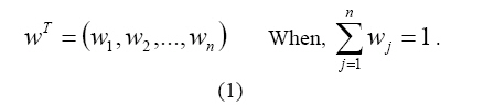
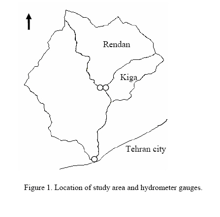
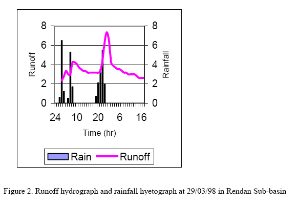
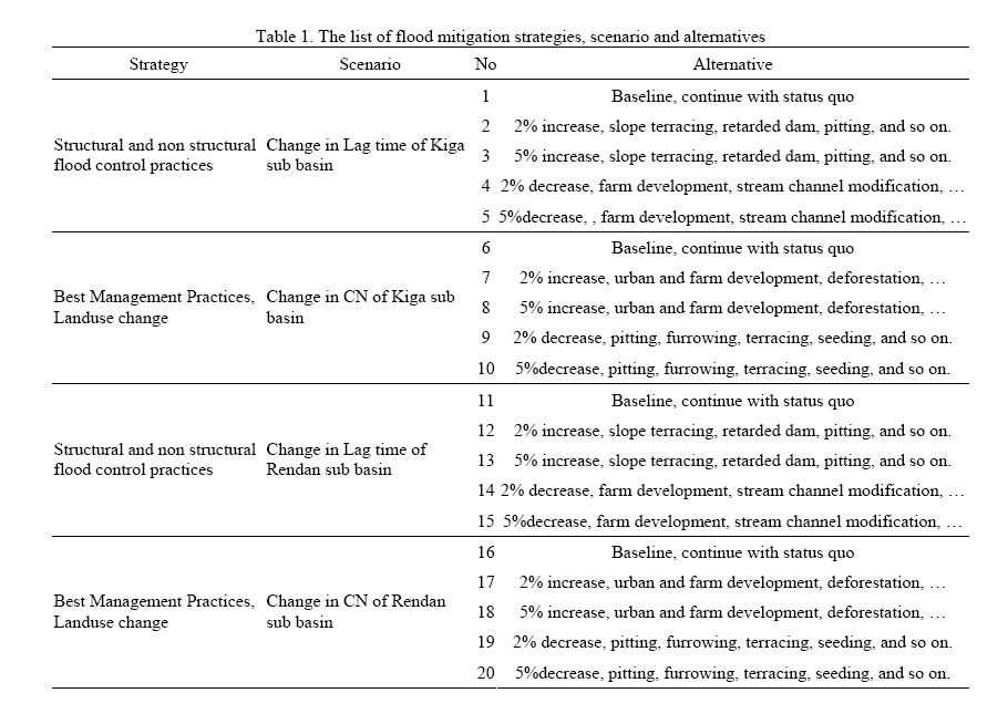
Journal of Applied Sciences and Environmental Management, Vol. 11, No. 4, 2007, pp. 113-117 Evaluation of flood mitigation alternatives using hydrological modeling GHANBARPOUR M. REZA Assistant professor, Faculty of Natural Resources, University of Mazandaran, Sari, P.O.Box:737, Iran. E-mail: m_ghanbarpour@yahoo.com * Corresponding author: Ghanbarpour M. Reza Code Number: ja07106 ABSTRACT Flood damage is one of the most important natural hazards in arid and semi-arid regions. Hydrological modeling is needed for integrated watershed assessment, determining the effects of upstream watershed disturbances and flood control measures on flooding. Historical flash floods threatening Kan watershed have shown that flood control measures are urgently needed to protect natural resources, tourist sites and metropolitans area. Kan watershed has two sub-basins with common outlet, which is caused accelerated impacts on peak flows and flood volumes in mainstream. This watershed is a very interesting case for study of synchronized flood hydrographs analysis and possible challenges for reducing the intensity of floods. In this paper, an event based hydrological model, HEC-HMS, was used to modeling the watershed response to any changes by structural and non-structural flood control measures and synchronized hydrograph analysis. A multiple decision-making method was used to find optimal flood mitigation alternative based on 25 and 100 years peak flood discharges and time lag between peak flood discharges at outlet of two sub basins. Synchronized hydrograph analyses have shown that flood control measures should not implement in Kiga sub-basin. For local flood mitigation at the Kiga sub-basin some methods for facilitating the flood flows were proposed. The analyses showed that magnitudes of the peak discharges downstream could be reduced if upstream peak flows are desynchronized. In these cases hydrograph analyses play the key role in rational flood mitigation planning. Flood control measures in a river basin include both structural and non-structural measures. Analysis of the performance of any flood control plan in flood damage reduction before actual implementation is an important aspect in flood mitigation planning as implementations of such measures involve a huge amount of financial and human resources, especially in structural measures. Flood control measures are essential in a watershed for reduction of flood damage. In planning of various structural and non-structural measures for flood control in a basin such as improvement of drainage network to increase carrying capacity, increase of the vegetation cover, etc., it is essential to carry out analysis to understand the impact of such measures in flood damage reduction and various scenario analyses are required to choose the best alternative. In such analysis, mathematical models can be viewed as a useful decision support system for planning of flood control measures. Dutta, et al, 2000, used a distributed hydrological model to analyse the impacts of a proposed flood control plan in a Japanese river basin to analyse its performance in economic flood damage reduction. The simulated results demonstrate that the model can be effectively used in flood control management activities in a watershed. In this paper Kan watershed was selected as a case study. Ghanbarpour et al. (2005) have shown flood mitigation is one the most preferred watershed management alternatives among all stakeholders of the Kan watershed. Historical flash floods threatening Kan watershed have shown that flood control measures are urgently needed to protect natural resources, tourist sites and metropolitans area. Kan watershed has two sub-basins with common outlet, which is caused accelerated impacts on peak flows and flood volumes in mainstream. This watershed is a very interesting case for study of synchronized flood hydrographs analysis and possible challenges for reducing the intensity of floods. In this paper, an application of a hydrological modeling system, HMS model, for analysis of some proposed flood control plans to desynchronized of flood at common outlet was presented. MATERIALS AND METHODS In this paper, Kan watershed as a mountainous watershed have chosen to present a case study for hydrological modeling related to the flood management purposes. In this watershed there are two sub-basins, which has common outlet and are very susceptible to flood events (Figure 1). The Kan watershed, which is 206 square kilometers, was selected for this study. This mountainous watershed is located approximately 5 Kilometers to the North West of Tehran, which is highly populated city. Topographically, the watershed is a mixture of mountain ranges, valleys and riparian area. Land uses are 68 percent rangelands, 22 percent rocky and barren lands, 8 percent agricultural lands and 2 percent villages, roads and others. Rangelands are confined primarily to the mountains. Agricultural lands dominate the narrow strips bordering streams and the valleys. This area also offers diverse recreational opportunities and contains a number of attractive tourism sites in upland areas. In this study, all research plans and previous works on the study area were gathered and reviewed, especially the recently integrated watershed survey project (JWRC, 2000; RTWC, 2001). The area suffered from damage caused by floods in 1954, 1994, 1995 and other event, in succession. Especially, the worst case occurred in May 1995, when water from two sub basin gather together and caused a very flash and heavy flood on lower and middle part of the basin (Hakimi Larijani, 1995; JWRC, 2000). The estimated damages were 320 millions rials and five persons died in addition to the much damages to the farms and gardens and roads. In this study the Hydrologic Modelling System (HEC-HMS) was used to simulate the watershed respond to rainfall events and simulate the flood hydrographs at the different alternatives. The HEC-HMS model was designed to simulate the rainfall-runoff processes of dendrite watershed systems at the Hydrologic Engineering Center of the US Army Corps of Engineers (2000). The program includes a variety of mathematical models for simulating precipitation, evapotranspiration, infiltration, excess precipitation transformation, base flow and opens channel routing. Rainfall-Runoff simulation has done by analysis of some real observed data and HEC-HMS model. In this study nine rainfall-runoff events were gathered and analysed. Data was included the hydrograph data from two neighbours gauges at the out let of Kiga and Rendan sub basins and also hourly rainfall from two rain gauges in both sub basins. For sake of brevity the data was not presented here. Figure (2) has shown the rainfall-runoff event at the 29/03/98, which is observed in hydrometric station in Rendun Sub basin. Model calibration is the process of adjusting model parameter values until model results match historical data. The process can be completed manually using engineering judgment by repeatedly adjusting parameters, computing, and inspecting the goodness of fit between the computed and observed hydrographs. To compare a computed hydrograph to an observed one, the model computes an index of the goodness of fit. In this study sum of absolute errors and percent error in peak were used to model performance evaluation and calibration. Impacts of structural and non-structural measures could be investigated based on time difference between sub-basins’ peak discharge by using the simultaneous hydrographs analysis at the common outlet. Hydrological impacts analysis as well as economical and social impact analysis is necessary for rational flood management at the watershed scale. Each flood mitigation practices have specific impacts on different parts of a watershed. Therefore hydrological modeling is first step for impacts assessment. As can be seen in Table 1, in this research a list of different strategy, scenario and related alternatives for flood mitigation at the common outlet of two sub basins were proposed. To find an optimal alternative for mitigation of flood intensity at the common outlet of two sub basins, a multiple decision-making method was used based on different criteria. A multiple attribute decision-making problem can be expressed in a matrix format. As Chen and Hwang (1992) expressed a decision matrix D is a (m*n) matrix whose element indicates the performance rating of alternative i, , with respect to attribute j, . Hence , I= 1,2…m is denoted by and the column vector, n, shows the contrast of each alternative with respect to attribute , as . The relative importance is usually given by a set of weights, which, are normalized, to sum to one. In the case of n attributes, a weight set is:
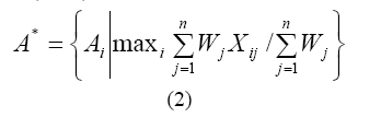
In this research, Simple Additive Weighting (SAW) method was used to find optimal flood mitigation alternative based on 25 and 100 years peak flood discharges and time lag between peak flood discharges at outlet of two sub basins. The overall score of an alternative in SAW method is computed as the weighted sum of the criterion values. For each alternative, score computation can be done by multiplying the scale rating of each criterion by its importance weight and summing these products over all criteria. The alternative with the highest score is selected. Mathematically, the most preferred alternative, , is selected such that:
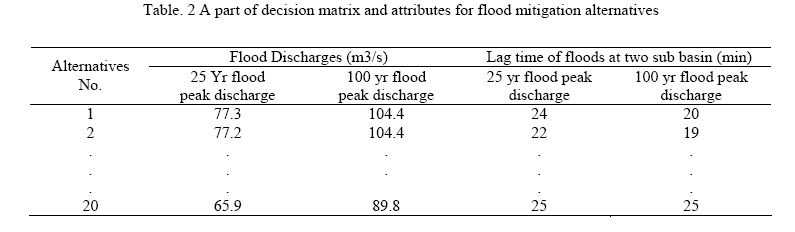
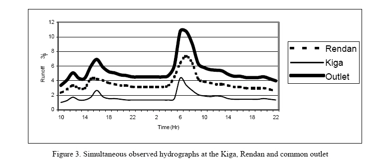
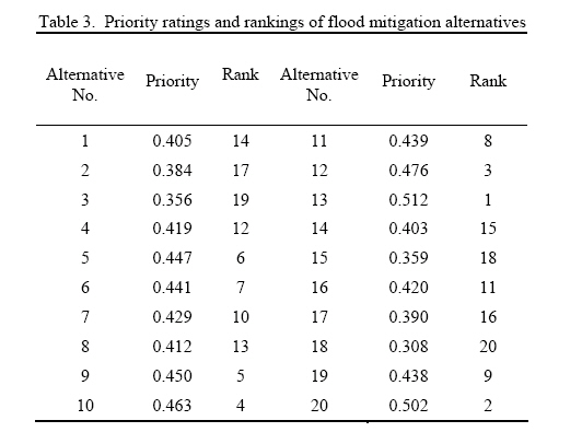
Where is the outcome of the ith alternative about the jth criterion with a numerically comparable scale, is the importance weight of the jth criterion. A part of decision matrix of the problem under study and all attributes was shown in Table 2. RESULTS AND DISCUSSION Historical flash floods threatening Kan watershed have shown that flood control measures are urgently needed to protect natural resources, tourist sites and metropolitans area. Our analyses showed that magnitudes of the peak discharges downstream could be reduced if upstream peak flows are desynchronised and also in the case where the sub-basins of a watershed have common outlet synchronized hydrograph analyses play the key role in rational flood mitigation planning. This analysis shown that peak discharge from two sub-basins is approximately simultaneous when there is not any primarily rainfall. But at the antecedent rainfall situations, Kiga produces peak discharge earlier than Rendan sub-basin, which is because of a little base flow contribution in flood in Kiga River. Also, this analysis has shown that structural and non-structural practices that will decrease the time of concentration should not implemented at the Kiga sub-basin. On the other hand, some river engineering practices to facilitate the passing flow in Kiga River was proposed. Figure (3) has shown simultaneous observed hydrographs at the Kiga and Rendan and common outlet for event at 24/03/02. HEC-HMS model was used to simulate the hydrological response at the two sub basins in Kan Watershed. Model calibration was done by using nine rainfall-runoff events at two sub basins. For evaluation of model performance two different events were used and the results were shown that this model can be used for hydrological analysis at these basins and it can simulate the hydrographs with low values of percent error. For example, the differences between observed and estimated peak and volume of flood discharge in Kiga sub basin are 10 and 1.2 percent, respectively. In Rendan sub basin the differences between observed and estimated peak and volume of flood discharge are 1.48 and 3.77 percent respectively. Synchronized hydrograph analyses have shown that flood control measures should not implement in Kiga sub-basin. For local flood mitigation at the Kiga sub-basin some methods for facilitating the flood flows could be applied. Moving and evacuation of local communities and villages that are near stream and inside the flooding areas is one of the most important ways to mitigate flood disaster in Kiga sub basin. On the other hand some suitable and possible structural measures such as Gabion and cement check dams and terracing can be proposed to delay in stream flow in Rendan sub-basin for decreasing the peak flows at the common outlet. Non-structural measures are included forestation, land use changes, range vegetation cover improvement that can be applied in Rendan sub basin. In This research the best flood mitigation alternatives were prioritised using SAW method. As can be seen in Table 1 and 3, among the structural and non-structural stream flood control strategies, change in lag time of Rendan sub basin using slope terracing, retarded dam construction, pitting and furrowing on rangelands is the most rated alternative. On the other hand, land use changes such as urbanization and farmland development, which will be caused an extensive deforestation could be the worst case among the management alternatives, especially in Rendan sub basin. REFERENCES
Copyright 2007 - Journal of Applied Sciences & Environmental Management The following images related to this document are available:Photo images[ja07106t3.jpg] [ja07106t2.jpg] [ja07106t1.jpg] [ja07106f3.jpg] [ja07106f2.jpg] [ja07106f1.jpg] |
| |||||||||
