 |
| About Bioline | All Journals | Testimonials | Membership | News |
|
||||||
|
||||||
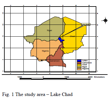
Journal of Applied Science and Environmental Management, Vol. 12, No. 1, March, 2008, pp. 101-107 Assessment of changes in Aerial Extent of Lake Chad using Satellite Remote Sensing Data 1Alfa, N.I; 1 Adeofun, C.O.; 2*Ologunorisa, E.T National Centre for Remote Sensing, Jos, Nigeria. Code Number: ja08015 ABSTRACT The study assessed the changes in the aerial extent of Lake Chad using satellite based data sources between 1963 and 2000. The results of the analysis show that Lake Chad has shrunk more than 95% of its area within the period of study. The study observers that aside from climatic variability, proliferation of dams, water supply and irrigation projects along the major rivers that drain into the Lake from the Nigeria Sector of the Lake are possible explanations for the drying of Lake Chad. The study recommends some research and development efforts to save Lake Chad from total extinction. @ JASEM Of the world’s major dryland regions, the Sahel is unique in that it displays multi-decadal desiccation or dryness during the period of instrumental measurements (Hulme, 1996). Annual rainfall in the Sahel since the 1960s has averaged between 300 and 500mm, compared to values of 400 and 600mm recorded in earlier decades this century. This represents a rainfall reduction of the order of 20% (Middleton and Thomas, 1997). The African continent has experienced striking fluctuations of precipitation on both recent and historical times scales. In its sub-humid regions, droughts are inevitable feature of climate (Nicholson, 1998). Lakes are important indicators of climate and environmental change. The lake’s fluctuations register the pulse of rainfall variability in the equatorial tropics (Nicholson and Yin, 1998). Lake Chad is one of the inland water body which has undergone dramatic changes in the last few decades (Nicholson, 1998). The Lake used to occupy an area of over 6,000km2 has now shrunk to less than 400km2 . The wetland of the Lake Chad basin is being regarded as the most threatened wetland in Africa (Nicholson, 1998) The need to study the response of this lake in terms of decreasing size in response to climatic variability has been stressed in the literature. (Hulme, 1996; Nicholson and Yin, 1998) The purpose of this study is to document the changes in the aerial extent of the Lake using satellite based data sources between 1963 and 2000 and to provide explanation for the changes observed. STUDY AREA Lake Chad is located at the juncture of the north eastern Nigeria, south eastern Niger Republic, south western Chad Republic and the northern extent of the Republic of Cameroon. Geographically, it is located within Lat 12°30 and Lat 14° 30; Long 13°00E and 16o00E, (see Fig 1) The lake which is located in Northern Central Africa covers almost 8% of the continent and spreads over seven countries. About 20% of the total area of the Lake Chad basin, or 427500 km2 is called the conventional Basin (42% in Chad, 28% in Niger, 21% in Nigeria and 9% in Cameroon) which is under the mandate of the Lake Chad Basin Commission. This commission was created in 1964 by the four member states with the objectives of ensuring the most rational use of water, land and other natural resources and to coordinate regional development. Lake Chad is a terminal depression with the seven basin countries grouped around it of which four are in direct contact with the lakes, and these are Nigeria, Niger, Chad and Cameron. In Nigeria, two sub-basin drain into the Lake.
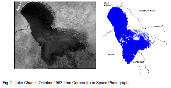
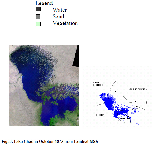
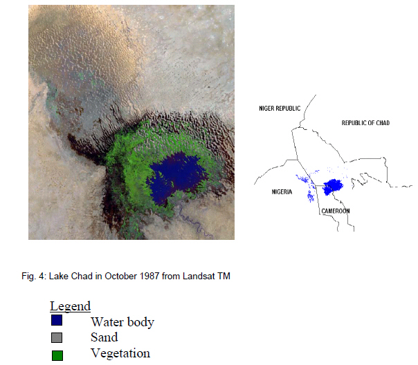
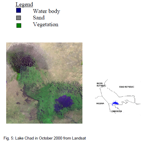
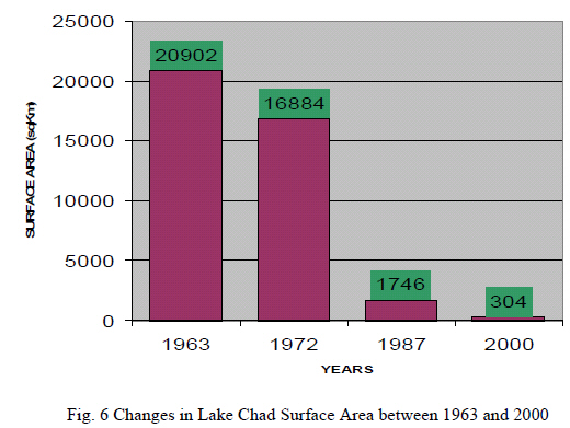
The Yedseram River and its tributaries rise in the Mandara hills and it ‘loses’ most of its water while flowing northwards through a 7-km-wide flood plain. Further downstream, together with the Ngadda River, it forms an 80-km2 swamp and does not maintain a definable watercouses to the Lake. The Komadougou/Yobe River is the border between Nigeria and Niger over the last 300km. Upstream of the confluence of the Hadejia and Jama are rivers the Hadejia-Nguru wetlands (fadamas) start. These covers a total area of about 6000km2 and a water surface area of about 2000km2. All rivers crossing this areas loose flow as a result of evaporation and evapotranspiration and infiltration to recharge the groundwater. The inflow is more than 2 km3/year, the outflow between 0.6 and 0.7km/year. When the inflow is more than 2km3/year, the outflow gradually increases to 1.2km3/year. At the upstream, the peak flow is at the end of the August and rises and falls rapidly reflecting the sporadic nature of heavy rainfall and the largely impermeable strata. Downstream the peak flow is in January. The flow into Lake Chad is about 0.5 km3 year. In Niger, in addition to the border Komodougou/Yobe River, there are the Koramas in the south of the country close to the border with Nigeria. These are seasonal rivers and their flow does not reach Lake Chad. METHODOLOGY The corona and Landsat imageries of Lake Chad for the year 1963, 1972, 1987 and 2000 acquired from the National Centre for Remote Sensing in Jos were used for the study. The water body was interpreted from the satellite imageries through an interactive process in ERDAS Imagine environment. The area coverage of water body was calculated for each year under investigation. This makes it possible for the changes in the aerial extent of the lake to be monitored over the years. RESULTS AND DISCUSSION The aerial extent of the lake in October, 1963 as interpreted from the corona space photograph is as shown in Fig 2. The water surface is evenly distributed within the adjoining four countries (Niger, Nigeria, Chad and Cameroon). The Lake surface was estimated to cover an approximate area of 20,900km2. Figure 3 shows the aerial extent of the lake as interpreted from Landsat MSS of 1972. The lake surface area was estimated to cover about 16884km2 during this period. The aerial extent of the lake in October 1987 as interpreted from Landsat TM is as shown in Fig 4. The blue colour representing water body has decreased significantly while the brownish colour depicting sand dunes has increased. The lake surface was estimated to cover about 1,746km2 at this period. Figure 5 present the lake water surface in October 2000 as interpreted from Landsat ETM. The brownish colour(sand dune) become more pronounced while the blue colour (water body) shrinks. The lake surface was estimated to cover abut 304km2 Figure 6, illustrate the trends of the lake surface area between October 1963 and October 2000, although the rapid process is seen to have slowed down between 1987 and 2000 because of the diminished evaporation surface, there is still a dramatic decrease in the lake size. YEARS Fig 6 Changes in Lake Chad Surface Area between 1963 and 2000 Since 1964, the lake level has continuously fallen with the surface area reducing from about 25,000km2 to less than 2000km2 while its volume has decreased by close to 60%. Lake Chad was once the sixth largest lake in the world, but its surface area has declined over recent decades to about 1/10 of its size in the 1960s. Severe drought in the 1970s and 1980s combined with diversions for irrigation, contributed to the shrinkage of the once-great inland sea. During the good days of Lake Chad, intensive irrigation and chemical application activities were practiced without consideration of the consequences. The construction of dams along the Challawa and Kano rivers and other water projects in the regions that drains into Kaodugu Yobe River, which subsequently enters the Lake Chad, may have also contributed to the dryness of the Lake region, apart from its excessive use of irrigation and the desertification of the surrounding Sahel environment. There are about 23 dams in the zone comprising Kano and Hadeija systems. Of all these, Tiga is the largest with surface area of 178km2 storage capacity of 1,988.00 mcm and catchments area of 6641km2; followed by the Challawa Gorge dam with surface area of 101.17km2, storage capacity of 969.00mcm and the catchments area of 3,859km2. These activities have marginalized the land in the sahel and adversely impacted on the environment in general and the lake in particular. Satellite data confirms that the most dramatic change and reduction in the lake size occurred between October 1963 and October, 1972 from 2290km2. Between 1972 and 1987, the greatest reduction occurred from 1684 km2 to a mere 1746km2, i.e. a drastic loss of about 1513km2. Coinciding with the drought periods 1972 to the 1980s in this region. The ripples on the northern parts of the satellite images indicate the lake itself once covered sand dunes formed by the winds. When it thrived, Lake Chad was one of those ironic points of planetary formation in that it seemed to defy the vast ocean of sand directly to its north. Located on the edge of the Sahara and bordering four countries – Chad, Cameroon, Nigeria and Niger – the immense area of this land locked lake has nearly disappeared in recent years. Persistent drought has caused the lake to drop from its former sixth place position in the list of the world’s largest lakes; it is now one-tenth its former size. The basin of the lake is not naturally deep, therefore the surface area of the lake tented to spread out, keeping the total depth to little more 23 feet (7 metres). In recent years, rainfall patterns have begun to change and tributaries to Lake Chad have not been refilling the basin as rapidly as in the past. Consequently, the productive flora and fauna fed by the wetlands of the shallow lake have suffered greatly. This has led to significant changes for various communities of people that lived in the vicinity of lake. While for some, the now exposed lake bed has provided new land for cultivation, much of the available fresh water that might have been used for irrigation is no longer available. As rainfall rates appear to be declining year after year, people living nearby develop even greater dependence on the lake. The history of human settlement is generally the story of a search for fertile land, abundant sources of water, suitable terrain, and climate with adequate growing season. Whenever nature supplies all these elements, human settlements flourish. On the other hand, when such conditions are scarce or disappear, communities are few and may eventually abandon the area. Specific consequences include the following:
Policy Options The amount of water flowing into Lake Chad from the Logone Chari river system is less than half what it was between the 1930s and 1960s because it has been diverted for other uses. Similarly the important Komadougou Yobe River, originating in northernNigeria, now flows to Lake Chad only during the rainy season. Severe droughts in the 1970s and 1980s, combined with diversions for irrigation, contributed to the shrinkage of the once great inland sea. The 8.3 million people living in Lake Chad basin who rely on it for drinking water, fishing, trade and agriculture, must constantly adapt to survive. Those living on Lake Chad’s shores are some of the more than one billion people globally who lack access to safe drinking water and proper sanitation. “The first step to turn the crisis around is to designate the lake a wetland of international importance,” said Martin Tchumba of World Wildlife Fund-Cameroon (WWF). “Countries must also adapt legislation to ensure the long term conservation of the Lake Chad Basin.”
Conclusion Lake Chad has shrunk more than 95% of its area within the period of the available data. The drying of the lake is moving at a fast rate of 1009.2km2 per year. In 1963, it covered an area of about 22,902km2; the Lake Chad has shrunk to about 304km2 that is less than 95% of what it was 30 years ago. This is indicated between the satellite images of October 1972 and October 1987 with a loss of 15138km2 in 15 years. Another possible reason for the drying of Lake Chad might be attributable to the proliferation of dams and other water supply and irrigation project along the major rivers that drain into the lake from the Nigerian sector of the lake. This might have contributed to the fact that the remaining Lake Chad water remained outside the Nigerian sector in recent times. A concerted effort is needed to embark on a very aggressive tree planting campaign and poverty alleviation programs in the border areas. To this end the national boundary commission and its counterparts in the affected counters together with the states concerned need to be involved to fashion out possible areas of cooperation. Lake Chad at the moment is already in danger of total extinction and the adverse consequences can only be imagined. Furthermore, research and development must be stepped up into the various problems of the environment involving desertification in the north, erosion in the east and the general deforestation going on this country. To be able to do this, timely and accurate information are required on the status and trends of socioeconomic and biophysical processes in our environment. Remote sensing and geographical information system offer operational means to the collection and extraction of multifaceted environmental data required by decision makers in a timely and efficient fashion. REFERENCES
Copyright 2008 - Journal of Applied Science and Environmental Management The following images related to this document are available:Photo images[ja08015f3.jpg] [ja08015f1.jpg] [ja08015f2.jpg] [ja08015f6.jpg] [ja08015f4.jpg] [ja08015f5.jpg] |
| |||||||||
