 |
| About Bioline | All Journals | Testimonials | Membership | News |
|
||||||
|
||||||
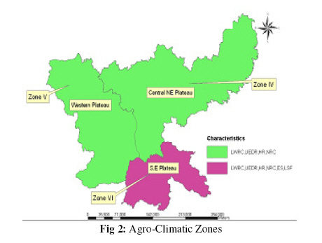
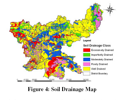
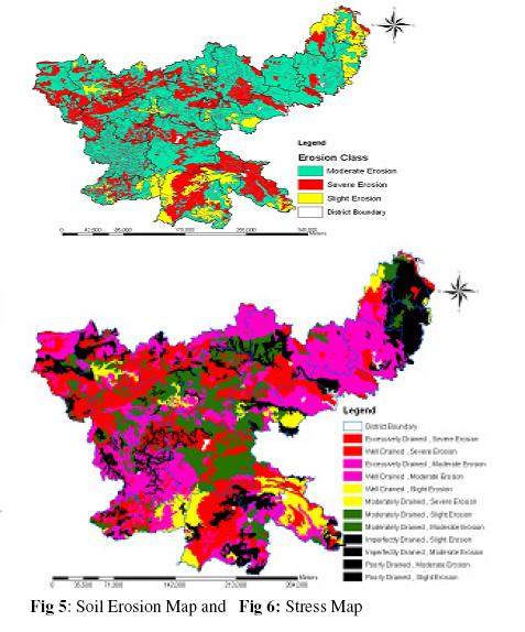
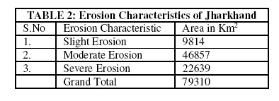
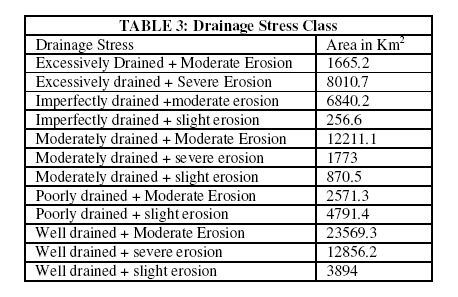
Journal of Applied Science & Environmental Management Vol. 15 No.1, March 2011, pp. 63 -67 Water Stress Assessment in Jharkhand State Using Soil Data and GIS Moushumi Hazra; *2Kirti Avishek; 1Gopal Pathak; 2Nathawat, M S 1Environmental Science & Engineering, Birla Institute
of Technology,
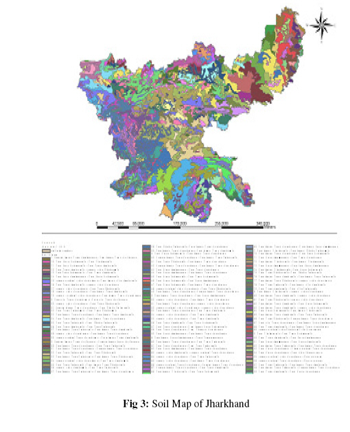
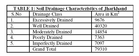
Mesra, Ranchi-835215.Jharkhand, India Code Number: ja11013 ABSTRACT In this paper an attempt has been made to study the interrelationship of water resources available with that of soil class and its properties including soil drainage and erosional characteristics which has been used to generate drainage stress map and water stress map inferring the basic reason for water scarcity in the district of Jharkhand, India. It has been found that 62.71% of soil is classified as well – excessively drained soils whereas only 18.13% of soil is imperfectly-poorly drained. It was also found that only 12.31% and 28.4% of total soil show slight erosion and severe erosion characteristics whereas remaining is moderately eroded. Jharkhand state is facing acute water crisis and due to lowering of ground water table. Thus this work would help the administrators and decision makers in assessing the role of soil in groundwater recharge. It has been concluded that soil is an important factor that controls ground water recharge and water stress of the region. GIS has proved to be an important tool in assessing the area in short span of time. An attempt has been made to highlight that there are various natural parameters that control ground water recharge and soil is one of the controlling parameter in Jharkhand (INDIA). The survival of all living things depends on the availability of water. The supply of this key natural resource in adequate quantity, quality and time is of utmost importance for survival (Bandyopadhyay J, Mallik .B.,2003).In view of increasing demand of water for various sectors, special emphasis is usually laid on for the proper utilization of water resources. Issues of water security has attracted greater importance in research and policy matter during last few decades (Gleick, 1993; Cosgrove and Rijsberman, 2000) along with growing interests in economics of water resources (Briscoe, 1996; Gibbons, 1986). As an integral part of land-water interactive cycle, ground water is largely an invisible resource, occurring in a range of water producing geological structures either as free flowing artesian water or as a static / nonstatic, confined / nonconfined resource ( Bandyopadhyay J, Mallik .B.,2003).Ground water plays an important role in moderating and modulating the water regime and surface ecosystems ( Newson, 1997:72). Infact any comprehensive water resource project should address the importance of subsurface water dynamics. Ground water has been a reliable source for freshwater for human consumption, irrigation and industrial uses. Ground water levels vary with rainfall, physiography, soil, drainage and climatic environment (Kateja A., 2003). Soil is that invaluable, diverse, and fragile natural resource at Earth’s terrestrial surface that provides for life support. Soil may be defined as “the unconsolidated mineral material on the immediate surface of the earth that has been subjected to and influenced by a genetic and environmental factors.” (Soil Science Society of America, 1965). Soil erosion is caused by non infiltrated water that runs of a field. It is astonishing that often the process of soil erosion and water infiltration into the soil is not well understood by scientists. Soil erosion by water and runoff is often accepted as an unavoidable phenomenon associated with agriculture on sloping land. But soil loss by erosion or runoff is not an unavoidable process. According to Lal (1982), occurrence of erosion damage on cultivated land is merely a symptom of land misuse for that ecological environment.It is infact the failure of farming methods adopted that is leading to widespread distribution of poverty, land degradation (Ochse, et al., 1961) and water scarcity due to lack of water infiltration (Govindaraju and Nagarathinum, 2007). Physical and chemical characteristics of soil influence the type and speed of runoff. These factors are influenced basically by amount, intensity and duration of rainfall, slope, vegetation and soil (Pinchamuthu C.S,1967). Soil splash seen on fence posts, or on walls in a field or plot of bare soil, is evidence of the force of large raindrops striking bare soil (Harrold, 1972). Meyer and Mannering (1967) reported that in one year, raindrops deliver to an acre of land an impact energy equivalent to 20 tons of TNT (50 t/ha dinamite). Research has shown that soil covered with plant growth is less susceptible to soil erosion (Roth,1985).Soil is thus an important component to be studied for analysing water infiltration, erosion and recharge rates. Thus water management measures should be taken for capturing the running water (Ramasastri K.S 2002) so that water stress is reduced. Thus the type of soil actually influences the infiltration capacity and ground water recharge.Thus water scarcity and stress could be attributed to the type of soil. Thus it is essential to study the soil units and their drainage class and erosion characteristic. Geo-spatial technology has emerged as a vital tool in the creation of environmental information system. Remote sensing and Geographical information system are the two basic components in the creation of environmental databases using geo-spatial technology. Remote sensing and GIS have proved to be an effective tool in soil and water resource assessment (Rinos et.al.; Salih et. al. 2006; Pandey et. al.,2003; Yarong et.al., 2002) and mapping. Integration of remote Sensing and GIS techniques provide reliable, accurate and upto date databases on land and water resources (Rao et. al.2007, Avishek and Nathawat, 2004, Avishek and Nathawat, 2008, Kirti et. al., 2008). Several thematic layers can be generated using GIS for water resource assessment (Govindaraju and Nagarathinum, 2007) and in the identification of driving forces of changes (Kirti et. al.2009). Based on these layers, resource status could be analysed. In this work an attempt has been made to assess the ground water status of Jharkhand state using soil data and GIS. The State of Jharkhand has been chosen as the study area and it occupies an area of 79,714 sq.km which lies between 22º to 25º 20' North latitude and 83º 20' to 87º 45' East Longitude.The average annual rainfall of the state is 1300 mm. However the highest rainfall recorded is 1830mm. Geomorphological features like plateaus of different elevations, valley, scarps, ridges hillocks etc. are dominant in the land of Jharkhand (Oraon P.C.2003). The drainage of Jharkhand is basically rain-fed and there is hardly any other source of water. Figure 2 shows the Agroclimatic region of Jharkhand. According to it the state has been divided into three zones. Characteristics of each zone is shown in the map. The overall utilization of the groundwater resource in the state is very low considering the low percentage of irrigation through groundwater (as irrigation is considered to be the highest consumer of ground water). Only 26.6% of groundwater resource in the state is used for various purposes whereas 73.4% remains untapped (Vision 2010 document-Jharkhand government). It can therefore be concluded that it is not actually the consumption pattern of water that is leading to water crisis in the region but other natural parameters that are affecting the ground water resources. The prime objective of this work was to study the various soil types in Jharkhand and to identify the recharging and erosional characteristics of soil using GIS. MATERIALS & METHODS The present work involves the study of soil as a prime component for identifying the water stress zones. Along with the soil data, agroclimatic data has been clubbed for Jharkhand to assess the emerging water crisis in the region. Step 1: Soil Map Generation: Soil Map was prepared according to NBSS (National Bureau of Soil Science) data. The map was digitized in ARC GIS 9.1 and georeferenced in Erdas 8.6 for geographical positional values.Soil map shows 99 classes of soil in the region. Step 2: Soil Drainage Evaluation: Soil Drainage refers to the outflows of water from soil. Natural soil drainage refers to the frequency and duration of periods when the soil is not saturated or partially saturated. Each soil unit obtained after digitization was then again classified according to soil drainage property. These properties were then added as an attribute using ARC GIS 9.1 and their statistical values and maps were generated in ARC Map catalog. Soil drainage was classified into poorly, imperfectly, moderately, well and excessively drained. Step 3: Soil Erosion Assessment: Soil erosion is the weathering away and the loss of topsoil due to the effect of wind or running water. Wind erosion is dominant in regions receiving less than 250mm of rainfall. Water erosion is a prominent feature in the region. Jharkhand has been classified broadly into slight, moderate and severe erosion regions. Step 4: Stress Assessment: Soil drainage and Soil erosion map were overlaid on each other. It showed the areas which are prone to mutiple of combination of drainage type and erosion type. Based on this stress map has been prepared. RESULTS AND DISCUSSIONSFigure 3 shows the Soil Classification map of Jharkhand. Based on soil classification soil drainage map was prepared as shown in Figure 4 and its corresponding statistics is shown in Table 1. Soil classes were again reclassified based on their erosional property and the corresponding map is shown in Figure 5. Table 2 shows the area statistics of individual erosion type. Soil drainage was divided into 5 classes depending upon the drainage properties of soil and then their area of occurrence found out. It was observed that area occupied by excessively and well-drained soil is 49,996 Km2 whereas poorly drained and imperfectly drained soil 14,460 Km2 indicating that majority of the soil does not allow infiltration of water and helps in quick runoff. Severe erosion has been found in 22,639 Km2 of study area whereas moderate erosion dominates with 46857 Km2 of area. When soil erosion and drainage characteristics was clubbed up and grouped together to get the drainage stress class. Figure 6 and Table 3 shows the stress map and area statistics based on soil drainage and erosion. According to the study it has been found that 50.58% of the soil drainage type is well drained and 12.13% of excessively drained. Thus it could be concluded that 62.71% of soil is classified as well – excessively drained soils followed by moderately drained soil drainage of 18.63%. It is also found that the poorly drained soil drainage is 9.23% as well as imperfectly drained 8.90%. It simply means that well drained soils are of highest percentage followed by moderately and excessively drained soil drainage thus not allowing the rainwater to percolate deep into the soil. Study area also witnesses moderate to severe erosion where moderate erosion occurs is 58.78% of area followed by severe erosion of 28.40% and slight erosion is restricted to only 12.31%. Therefore it is inferred from these values that moderate erosion is dominant in Jharkhand followed by severe erosion in most of the areas and only slight erosion in certain areas. Thus it can be inferred that most of the soil in Jharkhand are prone to severe erosion and are also well drained. It can be inferred that soil type in Jharkhand is not suitable for water recharge. As most of the water goes off as runoff the recharge into ground water is less. Soil in Jharkhand is thus one of the components responsible for water stress in the state. Thus steps should be taken to capture the running water. This can be done by adopting measures like contour bunding, water harvesting ponds and other physical methods. REFERENCES
Copyright 2011- Journal of Applied Sciences and Environmental Management The following images related to this document are available:Photo images[ja11013f3.jpg] [ja11013f2.jpg] [ja11013t1.jpg] [ja11013f5-6.jpg] [ja11013t2.jpg] [ja11013f1.jpg] [ja11013f4.jpg] [ja11013t3.jpg] |
| |||||||||
