 |
| About Bioline | All Journals | Testimonials | Membership | News |
|
||||||
|
||||||
Iranian Journal of Environmental Health Science & Engineering, 2008, Vol. 5, No. 1, pp. 43-50 PHYSICAL SPATIAL DEVELOPMENT: A GIS ANALYSIS WITH EMPHASIS ON ENVIRONMENTAL IMPACTS-CASE STUDY NALOS CITY, IRAN F. Naghibi, *H. Shirmohammadi Urban Planning and Design Department, Urmia University, Urmia, Iran Received 8 February 2007; revised 23 August 2007; accepted 3 October 2007 Code Number: se08006 ABSTRACT Unplanned urban developments have led to changes in uncontrollable urban spatial structure. For this reasons, informed guidance, principle organization and spatial planning are necessary for urban sprawl and development. In this research, different forms of urban development were considered and development basic barriers including rivers, topography, geology, ecological conditions, facilities andindustries were determined and the role of each one was surveyed. Development trends that are based on effective parameters especially environmental impacts were modeled with Geographic Information Systems. The quality of urban planning and management can be upgraded when available and valid data are handled in an advanced manner with the aid of Geographic Information Systems. The innovative technology can support planning and decision making by offering relatively quick response on analytical questions and monitoring issues. Experienced expert determined the degree and primacy of urban sprawl and development parameters generally and for nalos case study, these parameters and criteria and their weights were marked, then were modeled with Geographic Information Systems for nalos developments. With using GIS and it capabilities in calculation of land size forecasting for Nalos development and its positioning we could take a step in planning directions such as sustainable development achievements. Key words: GIS, planning, environmental impact, modeling, physical development INTRODUCTION Urban ever-increasing development, irregular population growing up and immigrations to the cities have led to unplanned and uncontrollable urban development and changes in urban space structure. For this reasons, informed guidance, principle organization and space planning are necessary for urban sprawl and development. A complete and logical planning for urban developments includes various processes like urban sprawl and resources, natural and human capitals without any bias or environmental rudeness that takes each of them into consideration which is required to use exact and update data. Planners are able to recognize natural and human environment changing with combination of different information. They can plan future priorities based on present conditions. Despite the awareness of undesirable effects of urban development on natural environment we must accept the fact that the urban development is inevitable. However urban growth (vertical) can meet some part of needs, Dominant development takes place in suburban where land use development caused exhausting the high quality of lands and destroying sensitive ecosystems. The urban development aim is increasing urban scale and so causing juncture in natural and artificial environment. Therefore such developments must be controlled and they are led to the correct directions, locations and achievement to other goals (such as socioeconomic problems that were caused migration) in urban development (Habibi, 2001). The urban development has different aspects in urban planning. Some of its important aspects are physical development and residential area spread and its services. In site selection, urban managers consider various criteria such as: land slope, visual aspect, topography, geology, distance from areas with earthquake potential, distance from rivers safety margine, roads and facilities bounds and other physical development obstacles such as orchard, agriculture lands and industrial zones (Natio, 2006 ; Badr , 2000). Many studies have accomplished about urban sprawl and development that in this research, we have used essential theories, experiences and results of these studies. Habibi K. and Badr R. have determined trend and pattern of physical sprawl and have noticed sprawl parameters such as slope and aspects of Sanandaj city (Habibi, 2001). Another study has accomplished by Forsythe that has performed urban development with using satellite images and has estimated urban development . In other cases, urban development has performed by putting priority parameters as environmental, landscape and transportation (Liu, 1998). Nowadays it is proved that efficient urban management is achieved by updated information about landuse, changing trends, activity type, physical development and so on. Various data resources and huge amount of them in urban management create many difficulties. In these cases, using modern and progressive technologies such as geographical information system (GIS) are taken into consideration by urban managers (Naghibi, 2006). Basic role of GIS is the capability of various aspatial and spatial data integrating, data analysis, data extraction and data output. In other word, GIS not only is the tool for data storing and classification, but it also distinguishes other systems because it is comparatively intelligent. Powerful analytical tools of GIS prepare complex analysis and data extraction (Modiri, 1999; Naghibi, 2006). GIS has been taken into consideration for supporting the urban management decision and these matters have caused development of GIS applications (Ready and Abdullah, 2003). GIS facilitates matters in urban studies and increases the efficiency of urban management with data collecting, updating, analyzing, estates and possessions management, construction permit issuance, traffic analysis, locating of optimum paths, locating for creation of general services. Recently GIS such as other new technologies has achieved a special position and has shown high efficiency in decision-making support. Another GIS capability that has been used by planners, managers and government decision makers are the most user of urban districts, proper service distribution, soil erosion modeling, land capability determining and so on (Shaeli, 1999). Answering to questions about problems in urban development, government desired intervention in urban lands, providing proper lands for land use planning and other question about urban planning are obtainable with GIS and GIS modeling. Using GIS in urban physical development is necessary because it helps urban managers to effective and correct planning and management. In addition of the GIS and its abilities in identification landuse changing, analyzing the obtained data are simple for determining the pattern of development (Habibi, 2001). This research has used models, functions and analysis with GIS tools in evaluating landuse, urban developments and its criterion establishment. Functional analyses of GIS that used in research consist of retrieval, classification, measurement, overlay, proximity, spatial orders and connectivity functions. ObjectivesEffective factors in physical development Slope is main parameter to residential region site selection for settling the buildings and streets settle in suitable slope. Whatever land slope is less, creation of routes, buildings and facilities perform easily because grading and land preparing costs become less. By the way residential environment has more desirability in habitation and traffic respect. For this, best slope is 0-5 percent. This classification is different based on region types. Also aspect can be effect in the urban development for decreasing energy usage. In north latitude if buildings settle on North Slope direction, energy requirement and lagging casts will increase. Slope direction to south and west south are warmest regions. East south and west slope directions place next degree viewpoint of warmth. Other slope directions are cold regions (Bear, 1999). Residential regions and routes must be avoided to place in undesirable wind directions. Also residential region settlements in upper heights made the services more hard and therefore the energy usages become increased. Regarding the soil composition is necessary for the urban development because land motions, land permeability and land mechanical resistance must facilitate establishment and buildings and facilities endurance. Underground and flowing waters must be protected against any wastage in the development process and any contaminated water that produced must be cleaned before returning to natural environment. Keeping aloof from existence faults and their bound consideration are necessary for protecting citizenry and decreasing costs of buildings and establishment safety in development process (Bear, 1999; Ready and Abdullah, 1999). Since many Iranian cities are constructed alongside the rivers, so preservation of these rivers is essential for urban living continue and so their bounds considerations cause their protection. The urban development should be keep aloof from urban facilities including water wells and resource, electrical insulations, gas and etc for citizenry presentation. In the case that urban development should perform nearby main roads, consideration of their limits is essential for safely area, road future development, facility cross and etc (Bear, 1999). Another parameters such as citizen tendencies and regions that have not more services can be effective in Nalos development. Environmental impacts in the urban development Urban development is the haphazard spreading of low-density residential, commercial, and/or industrial development into rural areas near cities. Sprawling development often results in several potential community and regional problems, including:
To prevent or control urban sprawl, planners, have to consider above problems in the planning of urban development (Shie, 1994). MATERIALS AND METHODS Forecast of land area for the urban development With attentive performed studies, Nalos is agricultural city with residential operation. So Nalos residential needs are the most important that are included 50 percent of Nalos area according to present standards. Basically with foresight of urban residential needs, Nalos development is accomplished. Statistical methods (regression analysis) in land size forecasting are used for urban development. Then by considering the population growth rate and low quality of residence number that will be gone out, residence numbers are calculated. This method has used in urban comprehensive plans for Iranian cities (Purmahmudi, 2000). E(t)=(HU)+H(t)+ru(t) E(t)=requirement residence number H=family number U=existence residence number H(t)=existence and new families number ru (t)= percent of residence number that will be destroyed and constructed in "t" time With attention to yearly urban growth rate (1.93) (Tosee and behsazi, 2005), population growth in 2005 (2455 people) and population growth in 2015 (future plan) has been estimated. It has taken as need forecasting foundation. Newly built residence number in 2015=(427-407)+85-345=450 Needed residence number without repairing of unenduring buildings =450-345=105 Residential area estimation method from point of culture is proposed for obtaining the needed land size with economical and cultural consideration that achieved the questionnaires. In this method many variants such as family, job, education, living type, record of urbanism and revenue rate were considered and given a privilege to any other. The privileges were given based on its important in residence planning process (Purmahmudi, 2000). Residence area average is determined by the privileges sum. Therefore substructure area average of Nalos is 154m2. Then parcel areas are calculated (Substructure area equal 60 percent of parcel area) and total requirement land area for Nalos development was calculates with residence number and parcel areas. 100/60×154=256 256×105=26680 m2 =2.7 hectares 2.7 × 2 (other 50 percent for establishing urban services) = 5.4 hectares
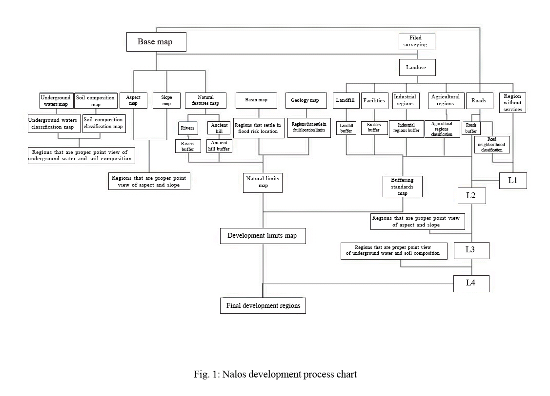
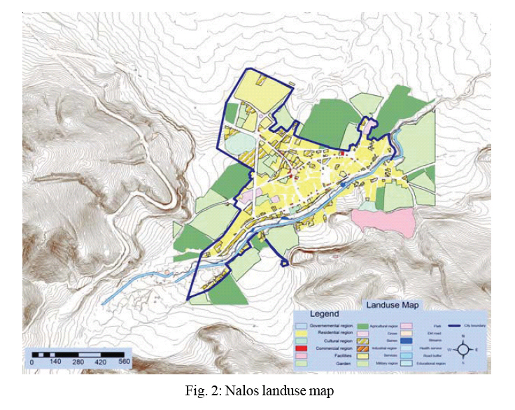
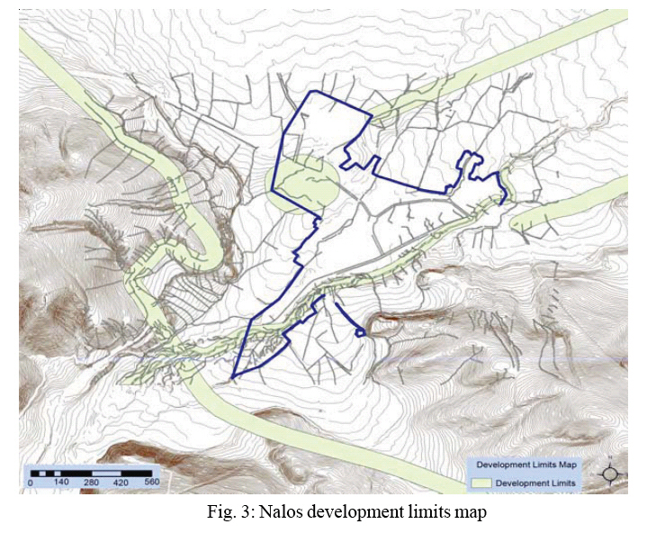
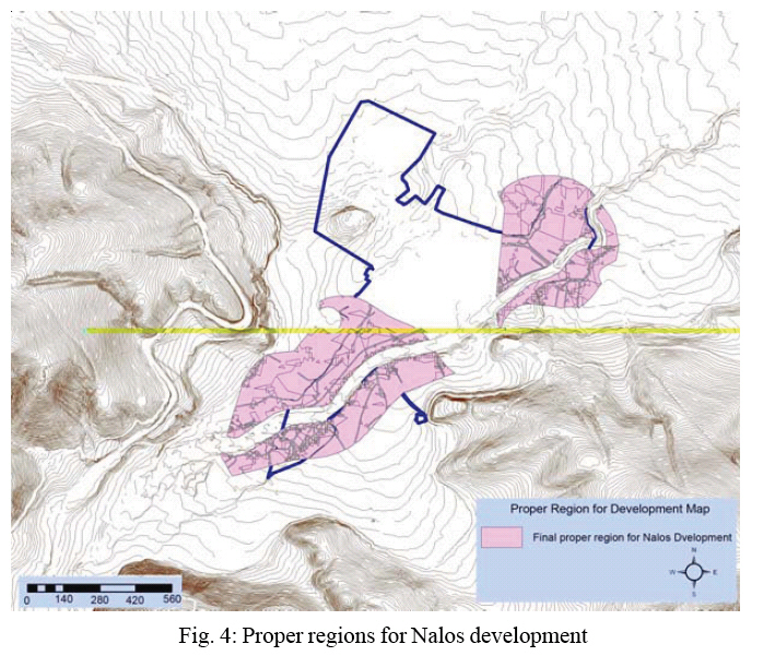
Recognition of case study Examination and determination of Nalos development directions is a case study in this research. Nalos is a small city in Oshnavieh County. Oshnavieh is city in west azarbayjan of Iran. Oshnavieh rests in west south of west azarbayjan. Its neighbors are Urmia, Naghadeh, Piranshahr and Iraq. Its area is about 1193km per m2.Also, tow river pass from inside (Kanirash River that pours to Gedarchai River, in fact Kanirash is counted as Gedarchai branch) and north (Gedarchai River) of it. Nalos is placed on mountainous region so that Ghuch, Zendan, Kanipis, Kanirash are surrounded it in south and west. Oshnavieh is terminated to Oshnavieh plateau in north (West Azarbayjan of Iran statistical yearbook, 2001). Matching inspection of urban construction theories in Nalos On the subject of urban formation theories, Nalos could be known either as formed linear figure or as half a radial figure. The river into south of nalos has caused linear developing at the river direction and its both sides that has gotten to city linear formation in south. Also existence of Masjed Jamee distinct (central and original part of village), its forms and available networks have caused the creating half radial network in Nalos. This same formation is proposed for future development with attention to topography, ecological conditions, optimum land using and developing people tendency directions (Tosee and behsazi, 2005). About the urban development, Nalos has not yet gained necessary urban dehiscence and in population respect it is considered town portion, so it is still need to have physical continuous development. Nalos is settled on development unit theories and its urban development could be continued in Kanirash River as far as Oshnavieh-Piranshahr road and reinforced its linear formation (Puab studies, 2003). Nalos development pattern alternatives Central-radial pattern (based on urban design of nalos, its form and Puab consultancy studies) is selected and in this aspect tow space organization can be considered for Nalos. a. Service centers are organized in around the town and Nalos present center b. Urban center are organized in physical form with consideration of nalos historical development process. Urban development of Nalos with GIS In this research by considering above parameters and pattern, urban development of Nalos is accomplished with GIS. This means that the development process is modeled in GIS (this model is based on Fig. 1 chart and implement in ArcGIS model builder) then corresponding data are prepared and are entered into planed model. In this process various layers are used with attention to mentioned parameters. These layers include: topographical map as based map (slope map, aspect map, roads, rivers, street, urban regions are extract it), geology and hydrological property and updated landuse map. These layers are entered in the following chart that it is prepared with authors for Nalos development model. In the next stage the chart is modeled with Model Builder extension of ARCGIS9 software. Then the model is run and its result is evaluated. Other attribute information such as population and standard capitations are entered in model too. Present capitations are compared with standard capitations. Therefore service faults (educational, commercial, cultural and etc landuse) were determined and its growth rate was clarified. This case with area size of Nalos (5.4 hectare) is considered in evaluation of proper region for Nalos development. Some primary data (Fig. 2, 3 and 4) and result of Nalos development lands and its direction are shown in the following. RESULTS In this research GIS is used as a powerful decision-making supporting tool in choosing different alternatives. The corresponding data are collected and stored in organized forms and then urban planning is performed via considering various conditions base on stable development goals. In the urban planning aspect, urban development parameters are determined and with using them and their weights the urban development is modeled by GIS (This modeling are accomplished in ArcGIS model builder). Meantime Nalos city from west Azarbayjan of Iran is selected for case study. Finally proper regions from Nalos city are become site selections that have urban development capability with considering kind of mentioned barriers, conditions and standards. Analytical capabilities of GIS are caused various layers integration, the process modeling and desired output producing that they are accomplished with high precise in the fast time. Traditional methods in urban development analysis could not use various factors and its effects but modeling in GIS can do this. In the research GIS modeling in urban development can utilize for other cities that have same Nalos city identification and with slight change in development parameters and data, model would answer and have best result. Nalos development results have specified lands for expansion that its properties be proper from the viewpoint of standard urban development. Area size of Nalos (5.4 hectare) is regarded in Nalos development. These results are shown in the following. DISCUSSION Physical-spatial planning define urban development aspects in each of research levels such as national, regional and local levels if have the necessary conditions for expansions or new cities creation. In evaluation of lands for future development, it is necessary to study physical and socio- economic conditions (Habibi, 2001). In the research, these cases are taken into consideration and are modeled by GIS techniques that with its help can recognize resource and potentials of Nalos development. In Sanadaj development, Habibi is considered topographic and geological conditions mostly (Habibi, 2001) but Nalos development aspects based on topographic, geological conditions and land use planning. Development of Nalos dissolve problem of its expansion, per capita land lack for various land use and environmental impacts. Adam Naito for predicting urban sprawl of southwest metropolitan Denver is used GIS analysis base on topographic conditions and the modeling is not performed but Nalos development model is accomplishment by Model Builder of ArcGIS. This modeling is caused that evaluation of result do rapidly and ability of process repetition and changing of limits is possible easily. Nalos expansion is considered environmental condition that other cases pay not attention to it. REFERENCES
© 2008 Tehran University of Medical Sciences Publications The following images related to this document are available:Photo images[se08006f4.jpg] [se08006f1.jpg] [se08006f3.jpg] [se08006f2.jpg] |
| |||||||||
