 |
| About Bioline | All Journals | Testimonials | Membership | News |
|
||||||
|
||||||
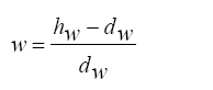
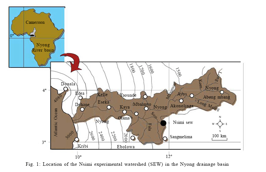
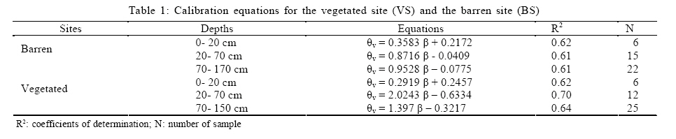
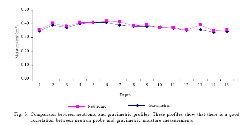
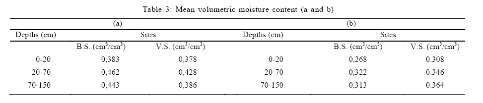
International Journal of Enviornmental Science and Technology, Vol. 6, No. 3, Summer, 2009, pp. 379-388 Transfer of moisture through the unsaturated zone in the tropical forest using the neutron probe 1 *A. T. Fouépé; 2 L. Kengni; 3 V. V. S. Gurunadha Rao; 4 J. R. Ndam 1 Institute for Geological and Mining Research-Hydrological Research Centre, PO Box 4110, Yaounde, Cameroon Received 4 December 2008; revised 14 April 2009; accepted 10 May 2009 Code Number: st09042 ABSTRACT Knowledge of moisture content is crucial in assessing spatial and temporal movement of water through the unsaturated zone. Moisture storage is also important for monitoring the soil water balance and for validation of water balance models. The purpose of this work was to determine and analyse moisture content profiles at point locations in the unsaturated zone of a lateritic soil around Nsimi, south of Cameroon. Neutron probe has been connected to a set of tensiometers in an area of 60 ha. A comparative study between a site covered with vegetation and a site uncovered was conducted to assess the influence of vegetation in the process of moisture transfers. The results showed that the spatial distribution of moisture profiles varied according to the site and the texture of the soil, with in general increasing of moisture from the surface horizon toward the deeper layers. The mean values of moisture varied from θm= 0,397 cm3/cm3 on barren site, against θm= 0,429 cm3/cm3 in vegetation. Values of suction were generally strong in surface and at depth, but weak in the intermediate layers. Keywords: Barren soil; Calibration; Lateritic soil; Neutron probe; Tensiometer INTRODUCTION The sustainable management of a natural ecosystem requires knowledge of different processes that are involved. The unsaturated zone plays a very important role in infiltration, deep percolation or recharge, water balance and the drainage systems because it is in this interface that exchanges of water, pollutants and microorganisms into the ground water or the atmosphere occur (Braun et al., 1997; 2005; Thais, 2004). The study of soil water must be addressed both in quantity and in terms of energy. Several methods are available for determining the moisture content of the subsurface zone: gravimetric methods, neutron thermalization and time domain reflectometry (Dalton, 1992; Healey and Cook, 2002). Although the first method leads in reshuffle of the soil, it is generally used as a standard for the other ones (Evett, 2004). Since the last few decades, the neutron probe has been widely used in Europe and America for determining the moisture content of the soil (Pourrut and Camus, 1970). It is convenient, fast, simple and it enables the instantaneous and continuous moisture measurement on the same point without disturbing the ground. However, this technology is rarely used in Sub Saharan Africa (Olivry and Sircoulon, 1998). Important work on the transfer of water in the unsaturated zone has been conducted in the past on this site using gravimetric methods (Fih, 1999). Disturbance of soil and non-recurrence of tests are the major disadvantages of this method (Fares et al., 2004). The concern is how to track variation in soil moisture on daily basis while respecting the soil structure. The major difference between this work and those already made at the site include the use of neutron probe that does not require the disturbance of soil and the possibility of continuous determination of moisture in the ground at fixed points. The method uses the real dry bulk density of soil, for determining the volumetric moisture content. The calibration of neutron probe is a very important task of this work. The objective of this study was to determine and analyze the moisture profiles in the unsaturated zone of the Mengong drainage basin by non-destructive method. MATERIALS AND METHODS Study area The data collection for this study was performed from June 11th of 2005 to May 8th of 2006. The Nsimi watershed lies on the southern Cameroon plateau and is situated at about 120 km to the South of Yaounde, near the Nsimi village in the tropical rain forest (latitude 3°10'N, longitude 11°51'E) covering an area of 60 ha (Fig. 1). It is made up of two convexoconcave sloped hills with average elevation of 700 m (amsl), both of which are separated by a marshy valley through which the Mengong brook passes with a mean annual discharge of 5 1/s (Viers et al., 1997). The annual rainfall varies between 1600 and 2000 mm with an annual average temperature of about 27 °C. The climate is of the Guinean type. Most of the catchment area is covered by a thick shrub. The vegetation appears locally deteriorated because of clearing forest for food crops. The vegetation is made of grass and trees that are always green. These sites have been chosen to highlight the influence of vegetation cover on the kinetics of moisture transfer between different horizons. The swampy depression is the domain of semi-aquatic plants like raffia or palm trees (Boeglin et al., 2003). The weathering mantle of this area (Fig. 2) is made up of very thick lateritic cover formed on hypersthene granites (charnokites) of Liberian age (2800 MA) belonging to the northern part of the Congo craton (Braun et al., 1998; Lasserre and Soba, 1979; Toteu et al., 2001). This weathered cover is differentiated into three main groups of horizons represented from bottom to top by very thick limono-sandy saprolite comprising the nodular horizon made up of ferruginous nodules with a dominantly clayey matrix, a superficial loose horizon rich in clay, overlain by a very thin humiferous layer. The bulk dry density of the soil at mid-slope where the study was carried out is 1.06 g/cm3 for the surface layers (0-20 cm) and 1.27 g/cm3 for deep layers (below 20 cm). This weathered cover is differentiated into three main groups of horizons represented from bottom to top by very thick limono-sandy saprolite comprising the nodular horizon made up of ferruginous nodules with a dominantly clayey matrix; a superficial loose horizon rich in clay, overlain by a very thin humiferous layer. The bulk dry density of the soil at mid-slope where the study is carried out is 1.06 g/cm3 for the surface layers (0-20 cm) and 1.27 g/cm3 for deep layers (below 20 cm). The hydraulic conductivity in the basin varying from 3.7e04 m/s on the higher hillside to 1.5 e06 m/s on the lower hillside (Sekhar et al., 2007). Gravimetric method When laying access tubes for neutron moisture probe depth, soil sample were taken at intervals of 10 cm. The collected samples were packed with aluminum foil and then weighed (hw). They were then dried at 105°C in an oven for 48 h and weighed again (dw). The weighted moisture content is given by the following equation:
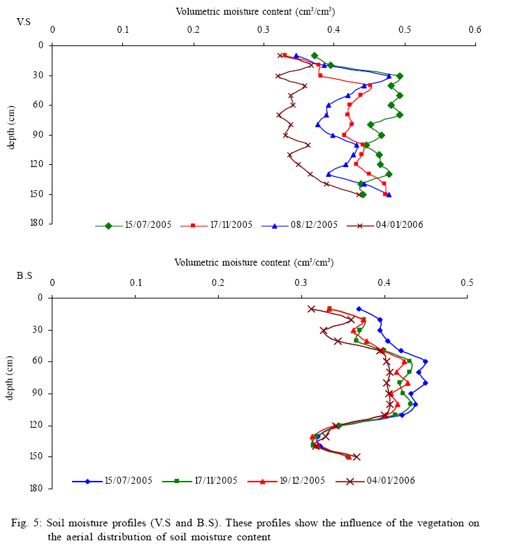
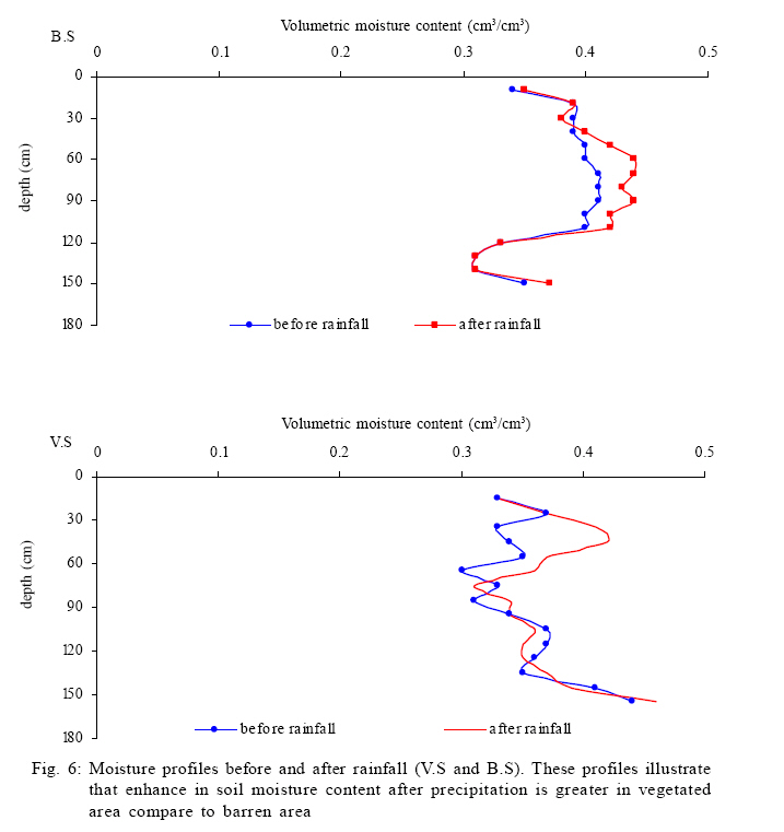
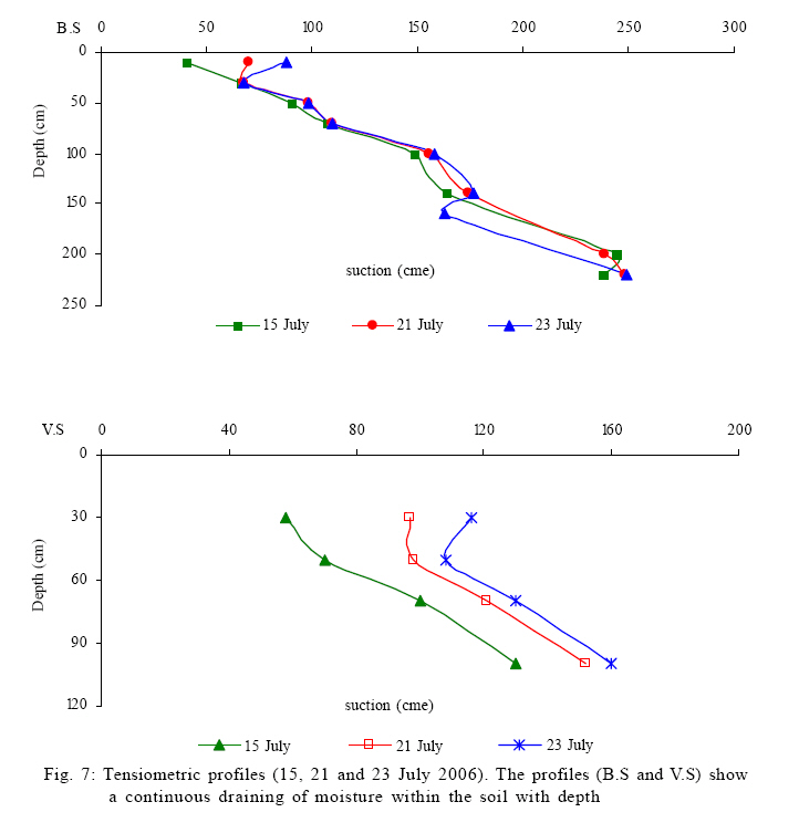
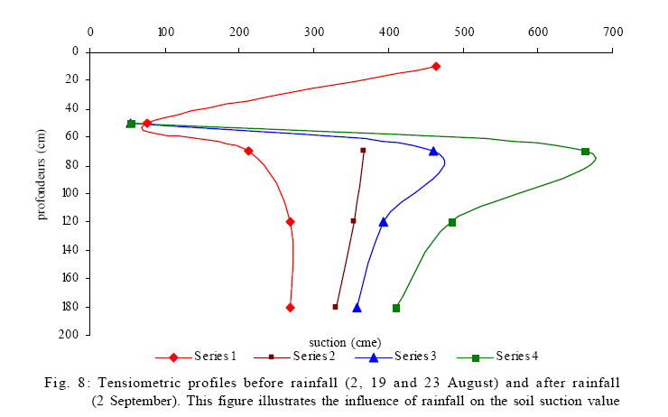
and the volumetric moisture was obtained from this equation: θv =da.w Where, θv: volumetric moisture content (cm3/cm3); W: weighted moisture (g/g); Da: bulk dry density of the soil. Neutron moisture probe A neutron moisture measuring probe using a sealed mixture source of radioactive americium 241 and beryllium with an activity ranging from 0.4 to 1.9 gigabequerels was used to measure the soil moisture content. Two hard aluminum tubes of 2 m each were implanted at two locations: one on barren area (B.S.) and another on vegetated area (V.S.). Measurements were made sequentially, leaving the probe at a depths Z (respectively at 15, 25, 35, 45, 55, 65, 75, 85, 95, 105, 115, 125, 135, 145, 155, 165, 175, 185 and 200 cm) for a period Ät = 65 s and registering the number of counts N. The probe was then lowered with an incremental of Äz = 10 cm and the same operations were repeated up to the base of the tube. In addition, to take account of the possible neutron drift, relative count values (β) were obtained from the equation: β=N/E, Where, E is the counting in the water in a container. Four measurements were performed per week. The calibration of the neutron probe was made by comparing the gravimetric measurements made during implementation of the access tubes and neutron counts measured by the probe (Reichardt et al., 1997). For every layer, a calibration curve was prepared using: θv=a.β+b Where, a and b refer respectively to the slope and the intercept of the regression line obtained while plotting θv = f(N) and θv is the volumetric moisture (Evett, 2003). By integrating the calibration equations following the depth, one gets the amount of water stored on the site at each measurement. The extrapolation of these data to the entire basin gives a value of the volumetric moisture content in the basin at the time. It is also possible to determine the amount of moisture stored or retrieved on a site between two dates, by differentiation of results. Tensiometers One can also characterize in another way the soil moisture by measuring the force that binds water to the rock or soil, what is known as capillary potential. The hydraulic tension or suction y measures the energy state and reflects the degree of saturation of soil. It is low in saturated soils condition and enhanced in dry soils. This positive suction value has been used to develop curves and profiles. At the experimental site in the Nsimi Basin, Multi-system tensiometric measurements were made using (STM 2150) tubes. Each site was equipped with a battery of tensiometers exploring various depths (10, 30, 50, 70, 100, 120, 140, 180, 200 and 220 cm). The hydraulic potential H, which is the height at which water could rise in a piezometer was obtained by: H=-12.6L+Y Where, L is the rise of mercury in the tube and Y is the distance between the level of mercury in the tube and the surface. Tensiometric measurements were carried out along with the neutron counting. The rainfall data were obtained from rain gauge installed on the area. Data analysis The critical examination of data was allowed to systematically eliminate some visual aberrations. All regression equations and statistical analysis were performed using statistical software SPSS 10.0. RESULTS AND DISCUSSION Calibrating the neutron probe and moisture profiles The review of the top soil explored by the neutron moisture probe revealed that there are two distinct layers (Fig. 2): the first from 0-70cm and the second from 70-200 cm. However, neutron losses in the atmosphere near the surface necessitated a separate calibration for the portion up to 20 cm (Evett and Steiner, 1995; Falleiros et al., 1993). Three straight calibration curves corresponding to respective soil layers were determined for each site (Table 1). Statistical analysis of experimental data showed acceptable correlations (p = 0.01) and indices of reliability of more than 0.67 (Table 2). The regression equations tended to have coefficients of determination R2 as 0.62 ≤ R2 ≤ 0.85. These equations were used for the transformation of neutron counts into volumetric moisture content. The observation of established profiles (Fig. 3) indicated that the neutronic method was slightly maximizing the moisture values at 110-140 cm depth. The results indicated that the moisture content varied in space and time with slight increases from the surface to depths. This same trend were obtained by Reedy and Scalon (2003) who used the electromagnetic induction to predict average water content of the soil profile at point locations in Texas, USA and by Vicente et al. (2003) during the comparison of soil water-contents measured with a neutron probe and time domain reflectometry in a Mediterranean forest of Central Western Spain. The measured average moisture content varied from θm=0,429 cm3/cm3 for vegetative area to θm=0,397 cm3/cm3 for barren site. This trend was also observed by Fih (1999) on the same site by the gravimetric method during the period from October 1998 to February 1999; He noted that the average moisture content varied from θm=0,339 cm3/cm3 for vegetative area and θm=0,302 cm3/cm3 on barren land. The difference could be attributed to the fact that the previous study was carried out in the rainy season while this study was carried out during dry season. At a given date, moisture content varied with depth; the maximum being in the middle layer (Table 3a and 3b). This can be explained by changes in hydrodynamic properties and grain size of the soil with depth. Indeed the saturated hydraulic conductivity (Ks) decreased rapidly from the surface to 30 cm depth (Fig. 4) (Kuitcha, 2002; Tienjo, 2007). It should be recall that the DOC concentrations measured in the soil by Braun et al. (2005) have been found also to be decreasing with depth. This can show the link between moisture and chemical transfer (Ndam, 1997). Moisture profiles variation with time generally followed the rainfall activity i.e after a rainy episode there was an increasing rate of moisture content. However, since the study period coincided with the transition wet-dry season, profiles trended to move from right to left (Fig. 5). The spatial distribution of profiles was different from one site to another. At vegetated area, there was a spread of the distribution of the profiles, whereas the phenomenon was slightly different on uncovered site. These results generally corroborated those obtained by Fih (1999). Moisture storage in soil profile By integrating equations in Table 1, one thus obtains from Table 3a, approximately 361 cm3 per surface unit of moisture storage under vegetated site against 323 cm3 per surface unit on the barren site. Apart from the influence of vegetation, this may be explained by the fact that the vegetated site has an average clay horizon thickness of 230 cm followed by a nodular horizon, compared to 180 cm for the barren site; but it was demonstrated at the site of Nsimi that clay horizon has a higher capacity of holding water with lower hydraulic conductivities under natural conditions than nodular horizon (Fih, 1999; Kuitcha, 2002; Tienjo, 2007). The results indicate that the moisture storage in vegetative area will be more than in barren site as vegetation provides good infiltration of water through roots (Norman and Gary, 1990). Expanding the investigation depth of the neutron probe could allow the possibility of measuring ground water recharge at depth where ground water is present. For this purpose, Maréchal et al. (2008) suggested an integrated approach coupling hydrogeological to geochemical monitoring. Kinetics of moisture movement The measurement carried out during October 2 and 9, 2005 had provided information for evaluating the behaviour of soil moisture profiles following the precipitation events. Between these two dates, 46.5 mm of rainfall had been recorded. It was observed that there was a superposition of the two profiles on barren site, for the 0-40 cm depths and beyond 110 cm and an enhancement (5 %) in moisture in the 40-110 cm zone after the precipitation. As the runoff was negligible and evapotranspiration limited, the increase in moisture content at depth 40 cm was probably due to infiltration (Fig. 6). A similar increase in moisture content was also observed on the vegetated site. In addition, it was observed that the moisture front (moving at variable speed of 5 to 26 cm/d), had moved deep into the soil on barren land. The presence of vegetation showed a significant influence on soil moisture content, as well as moisture movement. The variable residence time of water within the soil, creating an alternation of reducing and oxidizing conditions, affects soil chemistry, structure and lateral extension of the soil patterns (Temgoua et al., 2005). Tensiometric measurements Tensiometric profiles showed a marked and more individualized behaviour at the vegetated site (Fig. 7). The profiles showed a continuous draining of moisture within the soil. The barren site showed a linear progression, with higher moisture content at the surface and a gradual decrease with depth. A more detailed study of these variations at identical depths showed that the moisture content in vegetative site have always been at higher level than those in barren site at depth up to 180 cm. These are in conformity with the neutron moisture probe results and confirm that these two methods (tensiometric and neutronic) are adequate for taking moisture measurements. The influence of rainfall was very significant on vegetative site profiles (Fig. 8). The rains received before the last transactions were recorded on July 26 and August 23. This means that the profiles of August 2 and 19 took place during dry period. It was observed that the soil was very dry at the surface and slightly at lower depth on August 2. The drying up of layers of subsurface however continued over time. It was also observed with rainfall on August 23 and September 2 that there was switching of profiles on the surface, but a continuous and gradual drying at lower depth. This meant that the moisture front had not yet reached the layers at lower depth. There was a delay in moisture or drying on the two sites and the delay was more significant as the series of previous rainfall events were more distant . CONCLUSION Measurement of moisture content using moisture probe in the soils at the test site were accurately estimated using noninvasive method. The application of neutron thermalization in the study shows excellent promise for monitoring spatial and temporal variability in moisture content in a soil profile. The results indicated that the spatial distribution of profiles was influenced by vegetative cover and soil type. Although the surface moisture content was generally low, it has been noted a gradual increase in moisture content up to 110 cm depth in the both sites. The suction values were relatively strong in surface, strong in the intermediate layers and weak at depth. Although suctions were varied and moisture content different from one site to another, it was found that the soils of forest areas were quite wet and retained the moisture up to certain depth with time, particularly to the sites deprived of vegetation. However, it is suggested that the investigation depth of the study must be expanded to assess the possibility of measuring ground water recharge at depth where ground water is present. REFERENCES
© IRSEN, CEERS, IAU The following images related to this document are available:Photo images[st09042f2.jpg] [st09042t2.jpg] [st09042t1.jpg] [st09042f8.jpg] [st09042f5.jpg] [st09042f3.jpg] [st09042f7.jpg] [st09042t3.jpg] [st09042f6.jpg] [st09042f4.jpg] [st09042f1.jpg] |
| |||||||||
